Rajahmundry Fog
By Gp Capt (Dr) B Nandi 1.Rajahmundry is another place when morning poor visibility is…
By Gp Capt (Dr) B Nandi 1.Rajahmundry is another place when morning poor visibility is…
By Gp Capt (Dr) B Nandi Simplified horizontal/ two dimensional motion can be described by…

By Gp Capt (Dr) B Nandi Leh is situated in Indus valley in Ladhak, a…

By Gp Capt (Dr) B Nandi 1. Introduction To study the diurnal variation of atmospheric…

By Gp Capt (Dr) B Nandi 1.Rajahmundry is another place when morning poor visibility is common during winter. to understand occurrences we need to see the topography first. 2.Rajahmundry airport is situated East of Godavari river by about 6-7km distance and about 60 km West of Bay of Bengal. These are two major sources of…
By Gp Capt (Dr) B Nandi Simplified horizontal/ two dimensional motion can be described by the following equation. Where V is the wind velocity, f Coriolis parameter, ρ air density, P pressure. k vertical unit vector. First term is acceleration of air parcel, second term is Coriolis force and third term is pressure gradient force….
By Gp Capt (Dr) B Nandi Leh is situated in Indus valley in Ladhak, a difficult terrain to access by road. Though there are two highways one from Srinagar and other from Manali. Air way is boon for Leh. Kushok Bakula Rinpoche Airport is a public use airport located 2 km southwest of Leh, a…

By Gp Capt (Dr) B Nandi 1. Introduction To study the diurnal variation of atmospheric stability, Dubai wind profiler data is chosen. It is available at hourly interval from ground to 10000 feet for every 1000ft interval. Date chosen is 16JAN2023, a clear sky day with CAVOK weather throughout the day and night with minimum…
By Gp Capt (Dr) B Nandi 1.Introduction Usually temperature profile shows instability in the evening and stability/inversion during morning as a part of diurnal variation of stability. But there are occasions when instability of evening is carried forward to next day morning. Such occasions happened on 10JAN2024 and 11JAN2024. we need to identify the cause….
By Gp Capt (Dr) B Nandi Period chosen is 13JAN2024 to 15JAN2024 during a prolong period of fog from Punjab to Bangladesh as detected by Microphysics image. Morning extensive patch of fog image gradually dissolves during day and again starts forming in the night. Fog image of 13JAN2024 morning 0330 to 0357Z is shown below….
By Gp Capt (Dr) B Nandi METARs of Dehradun from 11OCT2023 to 16OCT2023 were undertaken for the study to demonstrate how useful it is to understand the atmospheric processes. Following are the METARs: 2. DEWPOINT JUMP On 11OCT2023, in half an hour (1200Z to1230Z) 3°C jump of dewpoint temperature from 15°C to 18°C has taken…

By Gp Capt (Dr) B Nandi 1.Introduction The atmospheric process that takes place in fog formation and temperature and dewpoint temperature variations is explained with reference to METARs of 06NOV2023 of Amritsar. On this day Minimum temperature was 160C and COT was 190C 2. Usually maximum temperature occurs in the afternoon around 2 to3 hour…

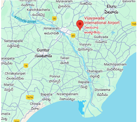
By Gp Capt (Dr) B Nandi Quite frequently Vijayawada experiences fog during winter season. I like to explain the occurrence as understood by me. Going to elaborate with two days data. We start the journey from the location and its surrounding. 2. Location Vijayawada airport is situated NE of Krishna river by about 10km distance…

By Gp Capt (Dr) B Nandi 1.Introduction. Few days we had fog over Mangalore during morning hours. 2. 10 Feb 2024 was day with fog 3. 11Feb 2024 also we had fog in the morning 4. 12Feb 2024 we did not have fog in the morning. 5.. Temperature profile for lower troposphere is given below….