By
Gp Capt (Dr) B Nandi
- Introduction
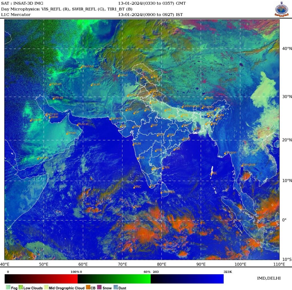
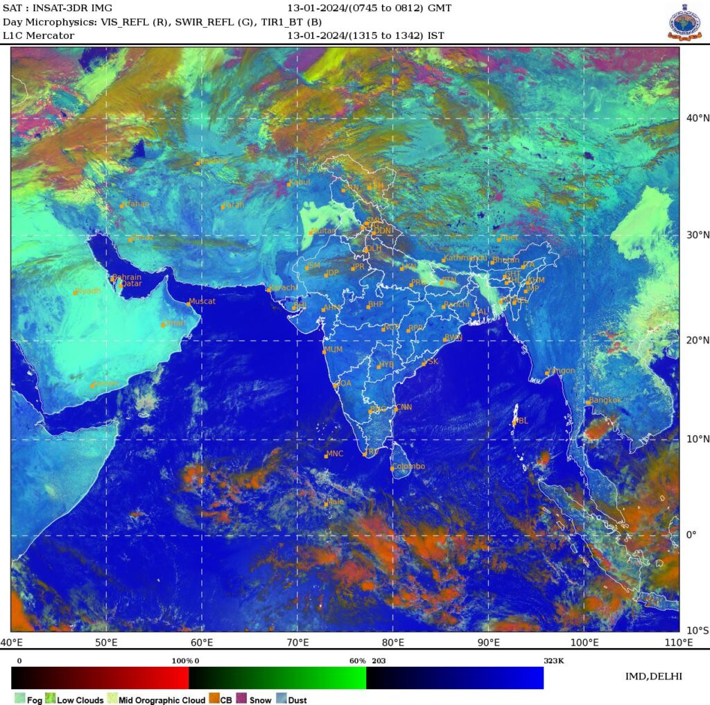
Period chosen is 13JAN2024 to 15JAN2024 during a prolong period of fog from Punjab to Bangladesh as detected by Microphysics image. Morning extensive patch of fog image gradually dissolves during day and again starts forming in the night. Fog image of 13JAN2024 morning 0330 to 0357Z is shown below.
On ground there was shallow fog over Delhi as shown by the below METARs
- VIDP 130130Z 08002KT 0400 R27/1900 R29L/1400 R29R/1400 FG FEW100 07/06 Q1017 TEMPO 0350 FG=
- VIDP 130200Z 00000KT 0400 R27/1100 R29L/0800 R29R/1000 FG FEW100 07/06 Q1017 TEMPO 0350 FG=
- VIDP 130230Z 00000KT 0350 R27/0900 R29L/0800 R29R/0900 FG FEW100 07/06 Q1018 NOSIG=
- VIDP 130300Z 00000KT 0350 R27/0900 R29L/1000 R29R/0900 FG FEW100 08/07 Q1018 NOSIG=
- VIDP 130330Z 00000KT 0350 R27/0800 R29L/0900 R29R/0800 FG FEW100 08/07 Q1019 NOSIG=
- VIDP 130400Z 00000KT 0500 R27/0900 R29L/1100 R29R/0800 MIFG FEW100 10/08 Q1019 BECMG 0600 MIFG=
Fog image area started dissolving during the day with solar heating, Image at 0745Z to 0812Z is shown below
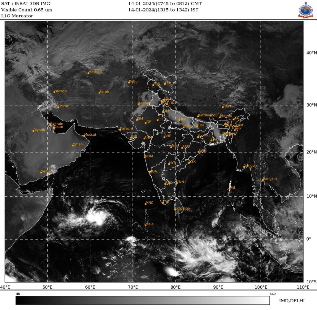
Extensive coverage of fog image returned next day morning 14JAN2024 as shown in the image of 0815IST (0245Z)
On ground there was dense fog over Delhi on 14JAN2024 as shown by the below METARs
- VIDP 132300Z VRB02KT 0050 R27/0350 R29L/0075 R29R/0075 FG VV/// 07/06 Q1015 NOSIG=
- VIDP 132330Z VRB02KT 0000 R27/M0050 R29L/0075 R29R/0050 FG VV/// 06/06 Q1016 NOSIG=
- VIDP 132230Z 00000KT 0050 R27/0700 R29L/0050 R29R/0600 FG VV/// 07/06 Q1016 NOSIG=
- VIDP 140000Z 26003KT 0000 R27/0075 R29L/0100 R29R/0075 FG VV/// 06/06 Q1016 NOSIG=
- VIDP 140030Z 26003KT 0000 R27/0100 R29L/0100 R29R/0100 FG VV/// 06/06 Q1016 NOSIG=
- VIDP 140100Z 28003KT 0000 R27/0125 R29L/0100 R29R/0100 FG VV/// 07/07 Q1017 NOSIG=
- VIDP 140130Z 26003KT 0000 R27/0100 R29L/0125 R29R/0100 FG VV/// 07/07 Q1017 NOSIG=
- VIDP 140200Z 24003KT 0000 R27/0100 R29L/0100 R29R/0125 FG VV/// 07/07 Q1017 NOSIG=
- VIDP 140230Z 23003KT 0000 R27/0100 R29L/0100 R29R/0100 FG VV/// 07/07 Q1018 NOSIG=
- VIDP 140300Z 25002KT 0000 R27/0100 R29L/0100 R29R/0075 FG VV/// 07/07 Q1018 NOSIG=
- VIDP 140330Z 24002KT 0000 R27/0150 R29L/0100 R29R/0100 FG VV/// 07/07 Q1019 NOSIG=
- VIDP 140400Z 24002KT 0000 R27/0225 R29L/0125 R29R/0125 FG VV/// 07/07 Q1019 NOSIG=
- VIDP 140430Z 25004KT 0050 R27/0325 R29L/0200 R29R/0350 FG VV/// 08/07 Q1020 BECMG 0150 FG=
- VIDP 140500Z 26004KT 0100 R27/0400 R29L/0250 R29R/0375 FG VV/// 08/07 Q1020 BECMG 0150 FG=
- VIDP 140530Z 26004KT 0150 R27/0600 R29L/0450 R29R/0500 FG VV/// 08/07 Q1019 NOSIG=
- VIDP 140600Z 25003KT 0200 R27/0800 R29L/0800 R29R/0800 FG VV/// 09/08 Q1019 NOSIG=
Fog image shown that it dissolves during day again as shown in visible image of 0800Z/14JAN2024
Extensive coverage of fog image returned next day morning 15JAN2024 as shown in the image of 0315Z to 0342Z
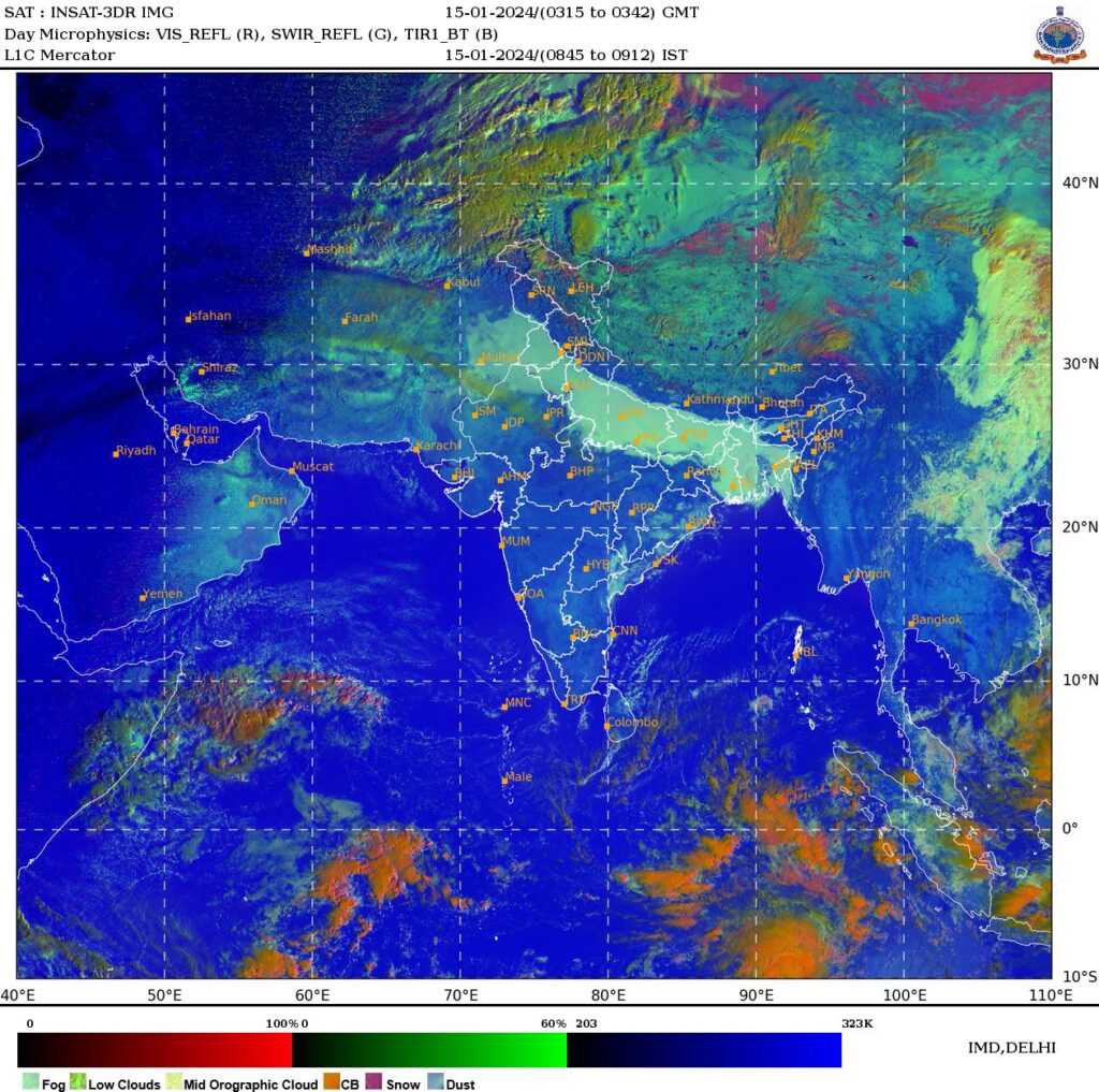
On ground there was dense fog over Delhi on 15JAN2024 as shown by the below METARs
- VIDP 142030Z VRB02KT 0150 R27/0600 R29L/0600 R29R/1300 FG VV/// 08/07 Q1017 NOSIG=
- VIDP 142100Z 23003KT 0050 R27/0175 R29L/0100 R29R/0100 FG VV/// 08/07 Q1017 NOSIG=
- VIDP 142130Z 25003KT 0000 R27/0375 R29L/0100 R29R/0075 FG VV/// 08/07 Q1017 NOSIG=
- VIDP 142200Z 24003KT 0000 R27/0100 R29L/0125 R29R/0100 FG VV/// 07/07 Q1016 NOSIG=
- VIDP 142230Z 00000KT 0000 R27/0125 R29L/0150 R29R/0100 FG VV/// 07/07 Q1016 NOSIG=
- VIDP 142300Z 25004KT 0000 R27/0150 R29L/0150 R29R/0125 FG VV/// 07/07 Q1016 NOSIG=
- VIDP 142330Z 24004KT 0000 R27/0175 R29L/0150 R29R/0125 FG VV/// 07/07 Q1016 NOSIG=
- VIDP 150000Z 24003KT 0050 R27/0175 R29L/0175 R29R/0125 FG VV/// 07/07 Q1016 NOSIG=
- VIDP 150030Z 26005KT 0050 R27/1000 R29L/0250 R29R/0250 FG VV/// 07/06 Q1017 NOSIG=
- VIDP 150100Z 24004KT 0050 R27/1400 R29L/0250 R29R/0450 FG VV/// 06/06 Q1017 NOSIG=
- VIDP 150130Z 23003KT 0050 R27/0700 R29L/0250 R29R/0300 FG VV/// 05/05 Q1017 NOSIG=
- VIDP 150200Z 24004KT 0050 R27/0750 R29L/0250 R29R/0250 FG VV/// 05/05 Q1017 BECMG 0150 FG=
- VIDP 150230Z 25003KT 0050 R27/0350 R29L/0200 R29R/0200 FG VV/// 05/05 Q1018 BECMG 0150 FG=
- VIDP 150300Z 26003KT 0100 R27/0225 R29L/0200 R29R/0200 FG VV/// 05/05 Q1018 BECMG 0150 FG=
- VIDP 150330Z 25004KT 0200 R27/0400 R29L/0200 R29R/0400 FG VV/// 05/05 Q1018 BECMG 0350 FG=
- VIDP 150400Z 26004KT 0350 R27/0800 R29L/0350 R29R/0350 FG VV/// 06/05 Q1019 NOSIG=
- VIDP 150430Z 25004KT 0500 R27/1200 R29L/0600 R29R/0900 MIFG NSC 06/05 Q1019 BECMG 0600 MIFG=
We need to forecast the occurrence of fog for next day morning by previous day evening. With this in mind the radiosonde ascent of Delhi from 12Z/13JAN2024 to 00Z/15JAN2024 has been studied.
2. Radiosonde temperature profile
Temperature profile as obtained from TEMP data of Delhi is presented below for 12Z/13JAN24 to 00Z/15JAN24 only for bottom 700m agl (above ground level).
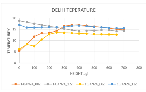
Observations.
- From 12Z/13JAN24 to 00Z/14JAN24 temperatures above 300m agl remained more or less same. While ground cooling during night after sun set resulted cooling below 300m, with maximum cooling at ground level from 170C to 5.40C, that is, cooling of 11.60C. At 100m agl temperature dropped from15.80C to 11.80C (40C cooling). This differential cooling resulted in morning inversion (5.80C at ground( 216m amsl) and 17.20C at 593m amsl) from evening instability (170C at ground( 216m amsl) and 15.80C at 264m amsl i.e. 250C/km lapse rate) near the ground.
- Hardly any change in temperature during the night above 300m agl indicates no advection of temperature and lack of moisture.
- From 00Z/14JAN24 to 12Z/14JAN24 during the day of 12 hours ground heating caused temperature to rise from 5.40C to 18.80C (a rise of 13.40C via rising to maximum temperature and then fall of temperature during late afternoon). Temperature rise has taken place below 300m agl with maximum rise at ground and minimum or nil rise at 300m agl. This resulted in low level instability (18.80C at ground( 216m amsl) and 170C at 362m amsl i.e. 12.30C/km lapse rate) a common feature for evening TEMP data.
- Slight cooling is seen above 300 m agl during the day indicating cold advection above 300m agl or cooling due to dissolving of elevated fog patch/ haze layer in the neighborhood.
- From 12Z/14JAN24 to 00Z/15JAN24 during the night very little cooling of the order of 1.20C seen above 300m agl. While cooling resulted below 300m with maximum cooling at ground level from 18.80C to 6.20C, that is cooling of 12.60C. At 100m agl temperature dropped from17.50C to 7.40C (10.10C cooling). This differential cooling resulted in morning inversion.
- Fog coverage dissolving and providing clear night results in good ground cooling and creation of morning inversion favouring dense fog formation. If that does not happen and elevated haze layer does not dissolve or elevated haze layer drifts in then ground cooling gets disrupted, moreover the evaporation of elevated haze layer results more cooling and even the evening instability may continue to next day morning. Will be shown in anther study.
3. Conclusion
- Usually the radiational cooling along with mixing due turbulence near ground takes place below 300m agl.
- The differential cooling and heating below 300m agl, results in morning inversion and evening instability on a clear day/night.
- Morning evening temperature difference can be 130C/140C
- Above 300m agl to 600m agl the layer of air is nearly isothermal whether morning or evening. A layer of air cannot be transparent to both short wave solar radiation and long wave terrestrial radiation. But can be in balance by absorbing and emitting radiation. To absorb solar radiation needs water droplet. Means that there was elevated haze layer which absorbed solar radiation and emitted same amount to retain its temperature during day and but, during night incoming radiation to this layer and transmitted amount must be same to continue as isothermal layer. The temperature at the bottom of the layer is not affected by ground cooling that is mixing with the ground and transparent to longwave because it is dry layer. Therefore, the process of haze layer evaporation to dryness must take place throughout the day by convection and advection. the dryness of the isothermal layer will be evident from RH profile
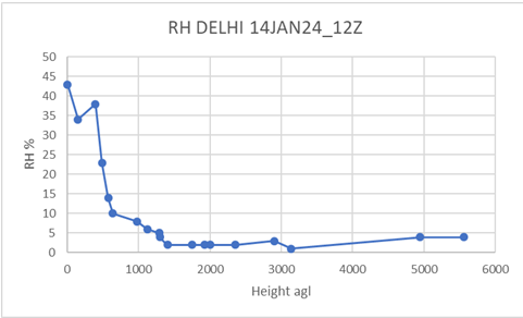
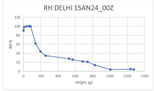
The above two Relative Humidity (RH) profile shows highly dry atmosphere above 600m. Moistening or high RH below 100m from evening to morning has two reason. Firstly temperature reduces near ground during night due radiational cooling where as dewpoint temperature change is hardly any. this effect increases the RH. Secondly the local water body sends moisture via counter current of land breeze during night, increasing the moisture. Thirdly ground cooling causes upward soil moisture flux during the night as interior soil remains at higher temperature. Dryness explains the occurrence of isothermal layer. This also indicates that the elevated haze layer as seen by satellite image must be occurring below 600m agl.