By
Gp Capt (Dr) B Nandi
1. Introduction
To study the diurnal variation of atmospheric stability, Dubai wind profiler data is chosen. It is available at hourly interval from ground to 10000 feet for every 1000ft interval. Date chosen is 16JAN2023, a clear sky day with CAVOK weather throughout the day and night with minimum temperature 18.00C at 0200UTC and maximum temperature as 25.00C from 0700 to 1200UTC. Sun rise time for Dubai on this day was 0343UTC ( Dubai Standard Time 0743DST) and sun set time 1350UTC (1750DST)
2. Ground to 1000 feet.
The variation of lapse rate ( 0C/1000ft) from ground to 1000 feet at hourly interval starting from 0030UTC to 2330UTC of 16Jan 2023 is presented in the following graph:
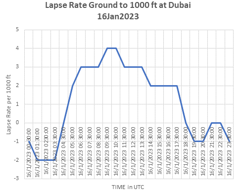
It can be seen that lapse rate is negative during early morning hours till morning 0430UTC. Lapse rate became nil at 0430UTC which is about 48 minutes after sun rise. Thereafter lapse rate continues to increase to 4.00C/1000ft at 0930UTC/1030UTC, peak hour of maximum temperature. After 1030UTC continued to reducing reaching nil 1830UTC, about 40minutes after sun set. from 1830UTC onward lapse rate is negative (inversion) or nil (isothermal) during rest of the night. . Peak Lapse 4.00C/1000ft, at 1030UTC, has occurred almost after 6hour 45min from sunrise time.
Considering 5.00C/km ( 1.510C/1000ft) as cutoff value for conditionally unstable atmosphere at temperature near 220C to 250C, it can be seen that atmosphere was unstable for moist air from 0530UTC to 1730UTC. Atmosphere was absolutely unstable (>9.80C/Km or 2.970C/1000ft) from 0630UTC to 1330UTC.
3 Features
- Positive Lapse rate – 0430UTC to 1830UTC, 45minues after sunrise to 45minutes after sunset
- Lapse rate above 1.510C/1000ft – 0530UTC to 1730UTC – unstable for moist air from morning to sunset
- Lapse rate above 30C/1000ft – 0630UTC to 1330UTC – absolute instability
- During night Lapse rate is -20C/1000ft or above, but not above 1.510C/1000ft, meaning that absolute stable condition prevails.
- Stability is night time feature and instability is day time feature.
4. Ground and above stability
To demonstrate the features 17JAN2023, a clear sky day with CAVOK weather throughout the day and night with minimum temperature 19.00C at 0100UTC and maximum temperature as 29.00C at 1100UTC. Only difference with 16JAN2023 is that, the surface was throughout was easterly, land to sea wind and thats how maximum temperature rose to 29.00C from 25.00C on previous day. The variation of lapse rate ( 0C/1000ft) from ground to 1000 feet, 1000ft to 2000ft and also for 2000ft to 3000ft at hourly interval starting from 0030UTC to 2330UTC of 17Jan 2023 is presented in the following graph:
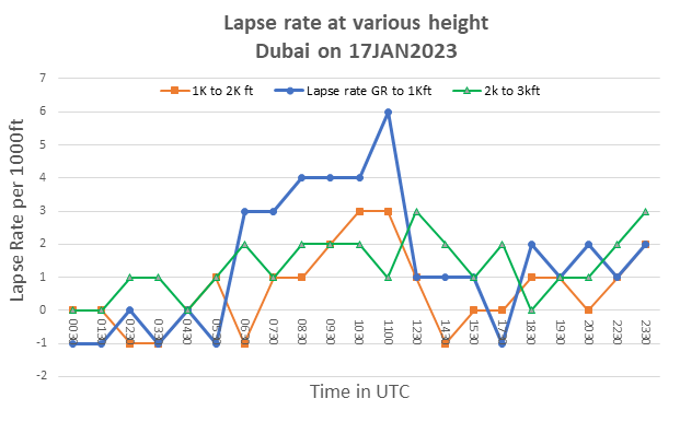
Above graph shows the diurnal variation of lapse rate between 1000ft to 2000ft (red) and 2000ft to 3000ft (green) along with lapse rate between ground and 1000ft (blue). It is noteworthy to see that Lapse rate at higher levels is all stable except for small window in the afternoon when conditionally stable lapse rate (1.510C to 30C/1000ft is seen, this is the time saturated air moves to higher level and gets trapped, to return back at later time to lower levels. At higher levels Lapse rate is never super adiabatic (>30C/1000ft) as seen for ground to 1000ft. Negative lapse rate (inversion) can be seen for 1000ft to 2000ft but not for 2000ft to 3000ft.
5. Response of heating at surface to Lapse rate
We may recall the formula for Buoyant acceleration when a parcel of air is heated up
a = (Tp -Te)g/Te
Where, a = acceleration of the parcel of air
Tp = Temperature of the parcel of air
Te = Temperature of surrounding air
g = acceleration due to gravity = 9.8 ms-2
Let us assume that temperature difference between an air parcel above a heated surface and its surroundings is 0.1K, which seems pretty reasonable, and that the temperature is 3000 K.
Then, a = (0.1)*9.8/300
or, a = 0.0033 ms-2
or, a=0.1fts-2
So, if the initial velocity of the air parcel is nil it will reach Z=100ft in time “t” given by the formula
Then Since Z= ½ a t2
by t = √(2 Z/ a) =2min
So now we can see that it takes a very small temperature difference to stir the planetary boundary layer almost in no time and parcel can reach 100ft in 46 second time. Dry parcel rises with DALR ( dry adiabatic lapse rate 2.970C/1000ft ). While rising it is likely to meet the environment which is warmer as environmental lapse rate will be less than DALR and will be decelerated and thus starts oscillating with Brunt-Vaisala frequency. As a result mixing process will start along with of parcel spreading with the wind. After a short while first 100ft will turn to a mixed layer with lapse rate as equal to DALR. Now this 100ft will become neutral layer and allow further rise to rising parcel of air through it. With this process continuing a layer of 1000ft may turn into a mixed layer with lapse rate equal to DALR.
Watch the graph, when prominent heating starts after 0530UTC the lapse rate quickly transform from nil to 30C/1000ft. by 0630UTC as long as air is dry. If moisture is sufficient at ground (say dew point depression is below 30C, the parcel of air will become saturated and may form cloud droplets. Evaporation of this cloud droplets may cause reduction in temperature and thus a super dry adiabatic lapse rate may generate.
6 Conclusion
- Like surface temperature, the Lapse rate above ground has diurnal variations.
- · Maximum lapse rate is seen around afternoon, while minimum occurs late in the night or early morning.
- · Super adiabatic lapse rate above ground is common in the afternoon in moist environment.
- · Super adiabatic lapse rate is not seen above 1000ft.
- · Diurnal variation reduces as we go up in the atmosphere Instability during day allows moist air to go up, while moist air near ground is not allowed to go up or move down due stability during night, remains confined in shallow layer near ground.