By
Gp Capt (Dr) B Nandi
1.Introduction
Usually temperature profile shows instability in the evening and stability/inversion during morning as a part of diurnal variation of stability. But there are occasions when instability of evening is carried forward to next day morning. Such occasions happened on 10JAN2024 and 11JAN2024. we need to identify the cause. This knowledge of carrying forward instability has great bearing in fog forecast. Radiation fog does not form in unstable environment.
2. Temperature Profile
Temperature profile for Delhi for bottom most 200m above ground level is shown below 00Z/10JAN2024 to 00Z/12JAN2024 from radiosonde data.
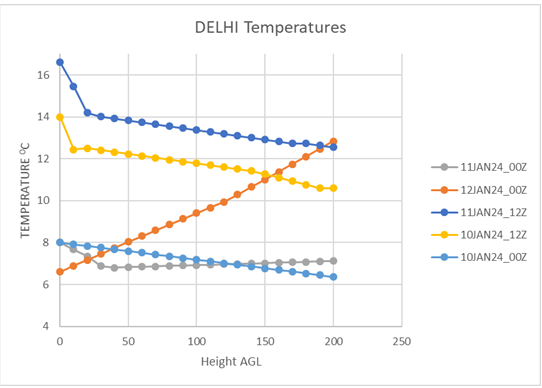
On 10JAN2024, the bottom most layer above ground was unstable/conditionally unstable on morning 00Z TEMP data (8.00C at ground level (216m amsl) and 5.80C at 485m agl, i.e 8.170C/km) as well as 12Z TEMP data (14.00C at ground level (216m amsl) and 12.60C at 225m agl, i.e 15.550C/km). increas in evening instability is usual occurrence. Now next day morning that on 11JAN2024 00Z TEMP, instability (8.00C at ground level (216m amsl) and 6.80C at 253m agl, i.e 32.430C/km) is carried forward. Quite obviously it was expected that 12Z TEMP of 11JAN2024 will be unstable ((16.60C at ground level (216m amsl) and 14.20C at 235m agl, i.e 126.310C/km). But morning 00Z TEMP data of 12JAN2024 clearly show strong inversion.
3. Visibility Condition
00Z TEMP of 10JAN2024 being conditionally unstable quite obviously visibility was not bad. METARS are as follows :
- VIDP 100030Z 28006KT 1200 R27/2000 R29L/2000 R29R/2000 BR NSC 08/08 Q1019 NOSIG=
- VIDP 100100Z 27006KT 1100 R27/2000 R29L/2000 R29R/2000 BR NSC 08/08 Q1020 NOSIG=
- VIDP 100130Z 28006KT 1100 R27/2000 R29L/2000 R29R/2000 BR NSC 08/08 Q1020 NOSIG=
- VIDP 100200Z 26005KT 1000 R27/2000 R29L/2000 R29R/2000 BR NSC 08/08 Q1020 TEMPO 0800 MIFG=
- VIDP 100230Z 27007KT 1000 R27/2000 R29L/1500 R29R/1700 BR NSC 08/08 Q1020 TEMPO 0800 MIFG=
- VIDP 100300Z 27006KT 0800 R27/2000 R29L/1500 R29R/1400 MIFG NSC 08/08 Q1020 NOSIG=
- VIDP 100330Z 26007KT 0800 R27/2000 R29L/1300 R29R/1400 MIFG NSC 08/08 Q1021 NOSIG=
- VIDP 100400Z 26006KT 0900 R27/2000 R29L/1400 R29R/1400 MIFG NSC 08/07 Q1021 NOSIG=
- VIDP 100430Z 26006KT 0900 R27/2000 R29L/1400 R29R/1400 MIFG NSC 08/07 Q1021 NOSIG=
- VIDP 100500Z 26006KT 1100 R27/2000 R29L/1500 R29R/1500 BR NSC 09/07 Q1021 NOSIG=
00Z TEMP of 11JAN2024 being unstable quite obviously visibility was not bad. METARS are as follows :
- VIDP 110000Z 27006KT 0100 R27/2000 R29L/1300 R29R/1000 FG VV/// 08/08 Q1019 BECMG 0150 FG=
- VIDP 110030Z 28007KT 0300 R27/2000 R29L/1300 R29R/1300 FG VV/// 08/08 Q1019 NOSIG=
- VIDP 110100Z 28005KT 0300 R27/2000 R29L/2000 R29R/1800 FG VV/// 08/07 Q1019 BECMG 0350 FG=
- VIDP 110130Z 28004KT 0500 R27/2000 R29L/2000 R29R/2000 MIFG NSC 08/07 Q1020 BECMG 0600 MIFG=
- VIDP 110200Z 28004KT 0600 R27/2000 R29L/1600 R29R/1600 MIFG NSC 07/07 Q1020 NOSIG=
- VIDP 110230Z 29005KT 0600 R27/1800 R29L/1400 R29R/1400 MIFG NSC 07/07 Q1020 NOSIG=
- VIDP 110300Z 28004KT 0600 R27/1900 R29L/1200 R29R/1300 MIFG NSC 08/07 Q1021 NOSIG=
- VIDP 110330Z 29004KT 0600 R27/1800 R29L/1200 R29R/1200 MIFG NSC 08/07 Q1021 NOSIG=
- VIDP 110400Z 29004KT 0600 R27/1800 R29L/1100 R29R/1200 MIFG NSC 08/07 Q1022 BECMG 0800 MIFG=
- VIDP 110430Z 27003KT 0900 R27/1600 R29L/1200 R29R/1200 MIFG NSC 09/07 Q1022 NOSIG=
- VIDP 110500Z 28003KT 1000 R27/1800 R29L/1300 R29R/1200 BR NSC 10/08 Q1022 NOSIG=
General visibility (human observation) though reported quite low but RVR was quite high where conditional pilot also can operate.
00Z TEMP of 12JAN2024 being stable (strong inversion) quite obviously dense fog returned. METARS are as follows :
- VIDP 112330Z 23003KT 0000 R27/0200 R29L/0225 R29R/0200 FG VV/// 06/06 Q1017 NOSIG=
- VIDP 120000Z 24004KT 0000 R27/0250 R29L/0300 R29R/0300 FG VV/// 06/06 Q1017 NOSIG=
- VIDP 120030Z 28004KT 0000 R27/0200 R29L/0700 R29R/0250 FG VV/// 06/06 Q1017 NOSIG=
- VIDP 120100Z 27005KT 0000 R27/0225 R29L/0200 R29R/0175 FG VV/// 06/06 Q1017 NOSIG=
- VIDP 120130Z 25004KT 0000 R27/0250 R29L/0300 R29R/0300 FG VV/// 06/06 Q1017 NOSIG=
- VIDP 120200Z 25004KT 0000 R27/0175 R29L/0175 R29R/0150 FG VV/// 06/06 Q1018 NOSIG=
- VIDP 120230Z 25004KT 0000 R27/0150 R29L/0125 R29R/0125 FG VV/// 06/06 Q1019 NOSIG=
- VIDP 120300Z 28003KT 0000 R27/0150 R29L/0150 R29R/0125 FG VV/// 07/06 Q1019 NOSIG=
- VIDP 120330Z 28002KT 0050 R27/0175 R29L/0150 R29R/0150 FG VV/// 07/06 Q1020 NOSIG=
- VIDP 120400Z 30003KT 0100 R27/0350 R29L/0325 R29R/0250 FG VV/// 07/07 Q1020 BECMG 0150 FG=
- VIDP 120430Z VRB02KT 0300 R27/0900 R29L/0750 R29R/0600 FG VV/// 08/07 Q1020 BECMG 0350 FG=
- VIDP 120500Z 26003KT 0500 R27/1000 R29L/1000 R29R/1000 MIFG NSC 08/07 Q1020 BECMG 0600 MIFG=
4. Question is why there was instability during the morning of 10 and 11JAN2024 and not on 12JAN2024? Usually the fog patch/ elevated haze does not allow solar radiation to penetrate and heat up the surface as evident from maximum temperature of 130C for Delhi (Palam) on 10JAN24. The intervening haze layer/fog patch absorbs the terrestrial radiation and evaporates. These cooling at some height of haze due to evaporation and return of terrestrial radiation to ground keeps ground warm and Lapse rate reaches instability. Same was expected to continue for 11JAN2024 night. But the difference is rise in Maximum temperature to 160C (30C more than previous day) indicate the drier layer above and dissolving of elevated haze layer/fog patch. Thereby, the intervening layer was missing and the terrestrial radiation can cause the ground cooling but not the cooling of elevated layer resulting in Inversion on 12JAN24 morning. The moisture profile of 10 and 11JAN24 00Z is shown below
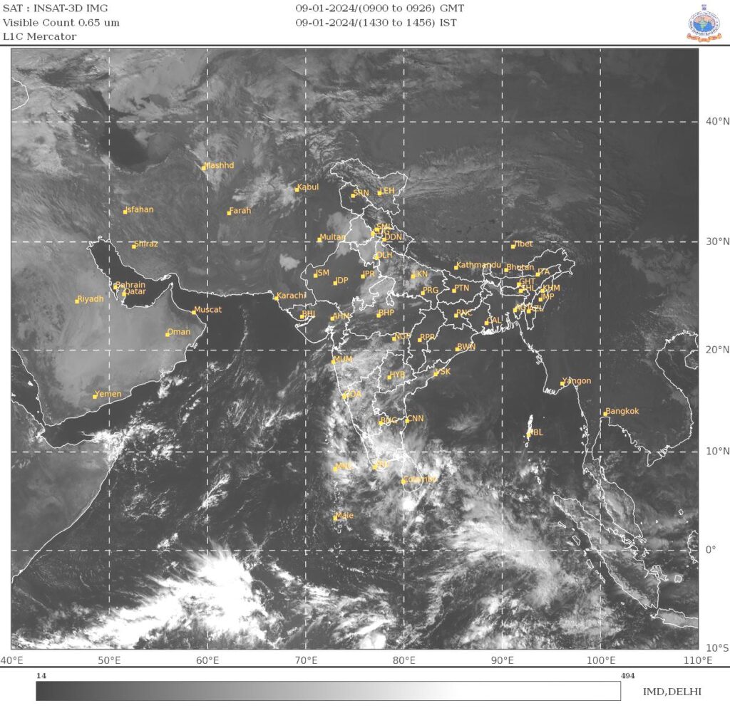
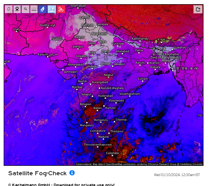
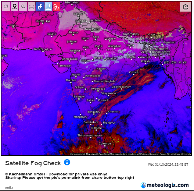
The visible image at 1430Z to 1456Z of 09 JAN2024 shows fog patch has not dissolved and midnight microphysics image shows elevated fog patch continued. satellite show fog but ground truth shows no fog, therefore it has to be elevated haze layer. Evaporation of this elevated haze layer keeps the temperature low at their height maintaining the instability near ground through the night. Similar thing happened on midnight of 110/11th. elevated haze layer was in close vicinity of Delhi as shown in the image below.
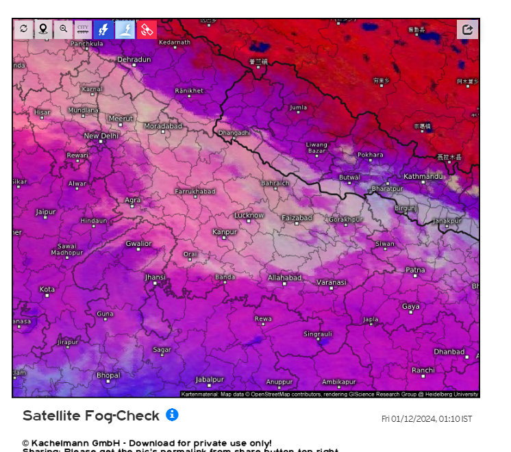
No such thing happened on 11/12th JAN2024 night it was clear and ground cooling was effected to form inversion in the morning, Around mid night image is shown below
5. Conclusion
If fog patch/elevated haze layer remains in the vicinity of the station during major part of night, its evaporation cooling maintains a steep lapse rate and instability inhibiting the fog formation. So it can be said that in the event of old fog patch/elevated haze layer during night fog formation on ground does not take place. Only occasion when instability is maintained but fog has formed is by advection/drift from neighbouring place.