By
Gp Capt (Dr) B Nandi
- Introduction
Quite frequently Vijayawada experiences fog during winter season. I like to explain the occurrence as understood by me. Going to elaborate with two days data. We start the journey from the location and its surrounding.
2. Location
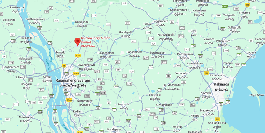
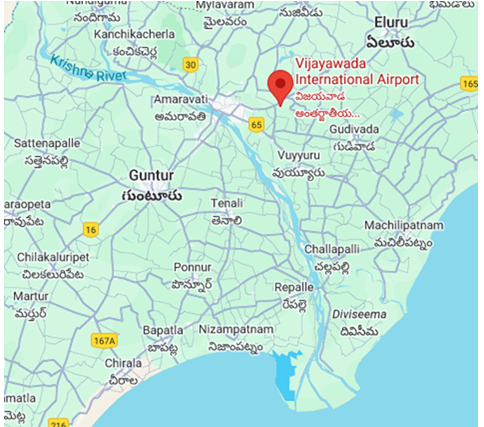
Vijayawada airport is situated NE of Krishna river by about 10km distance and about 70 km NW of Bay of Bengal. These are two major sources of moisture for Vijayawada.
3. Wind pattern
(a) During winter NElies prevail over eastern parts of Bay of Bengal at lower troposphere with anticyclone near Head Bay and ridge along East coast of India. Ridge is the zone of comparatively lighter wind and creates a fouvarable environment for fog formation. Wind pattern is shown below with the analysis chart of 00UTC, 14Feb2024 for 925hPa level.
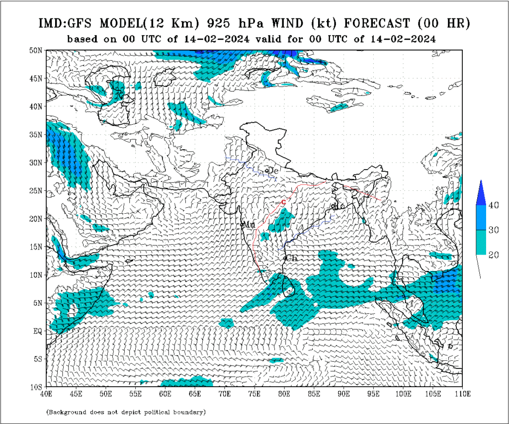
The lighter wind along the ridge allows the land sea breeze to dominate during their respective peak hours.
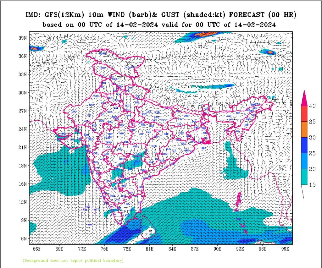
(b) 10m wind at 00UTC for 14 Feb2024 shows that anticyclone is over the head Bay giving rise to SElies to Orissa coast and NElies along Andhra Pradesh coast.
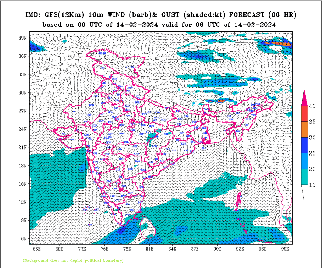
(c) 10m wind at 06UTC for 14 Feb2024 shows Elies or SElies during midday chart as Sea breeze starts dominating. NEly flow continues little away from the coast line.
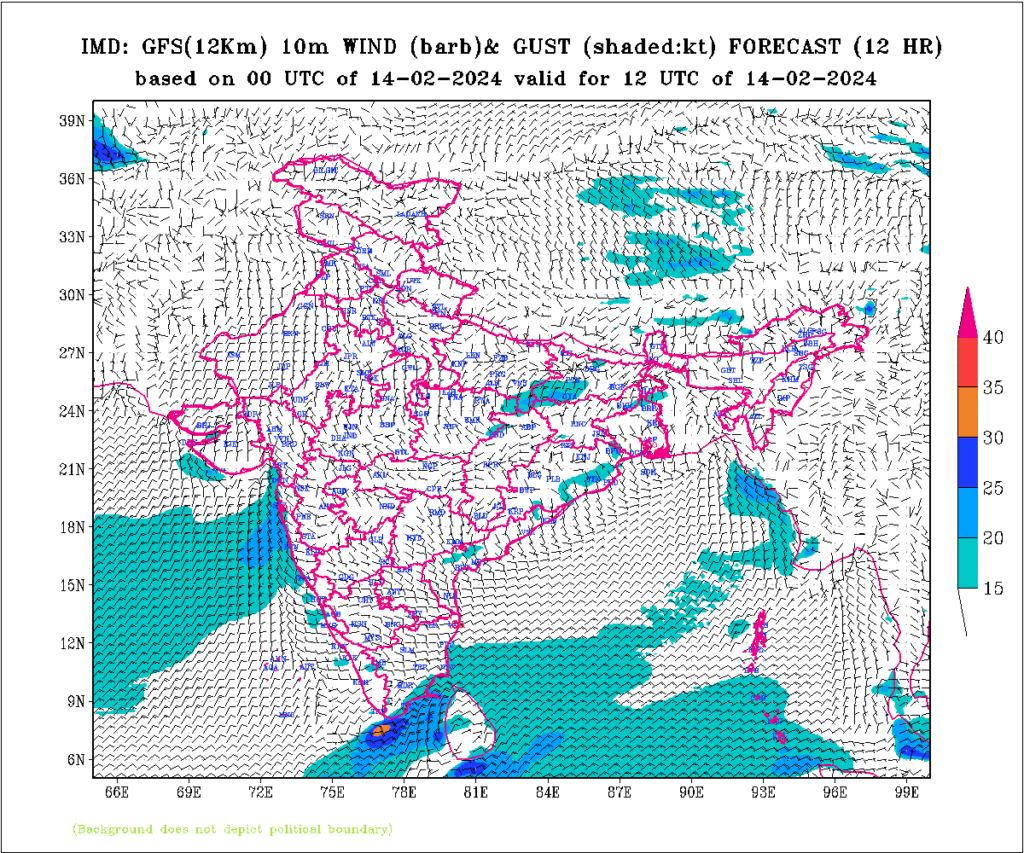
(d) 10m wind at 12UTC for 14 Feb2024 shows Slies or SElies perpendicular to coastline and the ridge moving further away into Bay indicating the dominance of Sea Breeze at peak hour for it. NEly flow continues little further away from the coast line.
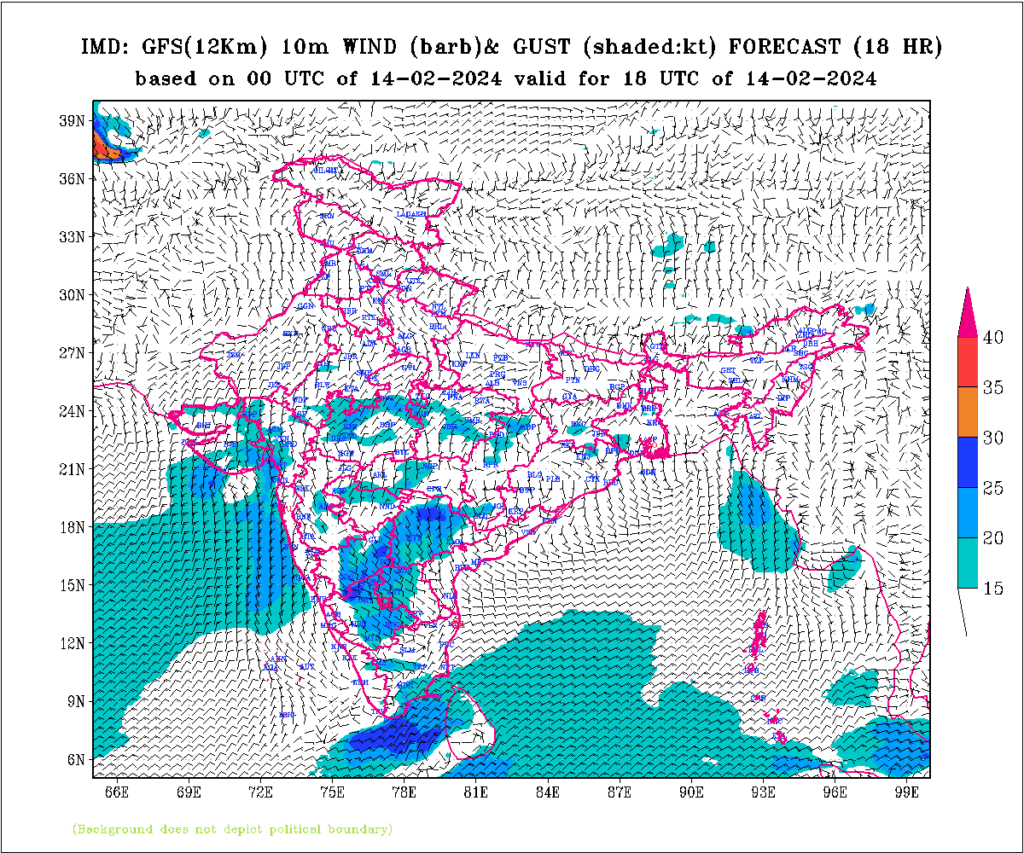
(e) 10m wind at 18UTC for 14 Feb2024 shows SWlies over norther parts of Andhra coast and ESElies on southern parts of Andhra coast. Ridge becomes deeper. Dominance of Sea Breeze reduces. NEly flow continues still little further away from the coast line.
4. Moisture
Throughout the day Moist air through southern Andhra coast moves towards Vijayawada as SElies prevail from 10m to 925hPa. Dew point temperature varies between 180C to 220C. Minimum dewpoint is during minimum RH phase (1700-1800h) and maximum dewpoint is during maximum RH phase (0830h). Visibility in general reduces to 1000m almost monotonously every day.
5. METARs
(a) 15 Feb 2024 was dense fog day for Vijayawada so let us watch the METARs from midday of 14 Feb 2024.
- VOBZ 140530Z 11006KT 6000 FEW020 28/21 Q1017 NOSIG=
- VOBZ 140530Z 11006KT 6000 FEW020 28/21 Q1017 NOSIG =
- VOBZ 140600Z 11005KT 6000 FEW020 30/20 Q1017 NOSIG=
- VOBZ 140600Z 11005KT 6000 FEW020 30/20 Q1017 NOSIG =
- VOBZ 140630Z 11005KT 6000 FEW020 30/20 Q1016 NOSIG=
- VOBZ 140630Z 11005KT 6000 FEW020 30/20 Q1016 NOSIG =
- VOBZ 140700Z 11005KT 6000 FEW020 SCT100 30/20 Q1016 NOSIG =
- VOBZ 140730Z 11005KT 6000 FEW020 SCT100 30/19 Q1015 NOSIG =
- VOBZ 140800Z 09005KT 6000 FEW020 SCT100 31/19 Q1014 NOSIG=
- VOBZ 140800Z 09005KT 6000 FEW020 SCT100 31/19 Q1014 NOSIG =
- VOBZ 140830Z 10006KT 6000 FEW020 SCT100 31/19 Q1014 NOSIG=
- VOBZ 140830Z 10006KT 6000 FEW020 SCT100 31/19 Q1014 NOSIG =
- VOBZ 140900Z 09008KT 6000 SCT100 31/20 Q1013 NOSIG =
- VOBZ 140930Z 11005KT 6000 SCT100 31/20 Q1013 NOSIG=
- VOBZ 140930Z 11005KT 6000 SCT100 31/20 Q1013 NOSIG =
- VOBZ 141000Z 11008KT 6000 SCT100 32/21 Q1013 NOSIG=
- VOBZ 141000Z 11008KT 6000 SCT100 32/21 Q1013 NOSIG =
- VOBZ 141030Z 13008KT 6000 SCT100 32/21 Q1013 NOSIG=
- VOBZ 141030Z 13008KT 6000 SCT100 32/21 Q1013 NOSIG =
- VOBZ 141100Z 14009KT 6000 SCT100 32/21 Q1013 NOSIG=
- VOBZ 141130Z 13008KT 6000 SCT100 31/21 Q1013 NOSIG=
- VOBZ 141130Z 13008KT 6000 SCT100 31/21 Q1013 NOSIG =
- VOBZ 141230Z 13005KT 6000 FEW100 28/18 Q1014 NOSIG=
- VOBZ 141300Z 14005KT 6000 FEW100 27/18 Q1014 NOSIG =
- VOBZ 141330Z 13005KT 6000 FEW100 26/19 Q1014 NOSIG=
- VOBZ 141330Z 13005KT 6000 FEW100 26/19 Q1014 NOSIG =
- VOBZ 141400Z 13004KT 5000 HZ FEW100 25/19 Q1014 NOSIG =
- VOBZ 141430Z 13003KT 3500 HZ FEW100 25/19 Q1015 NOSIG=
- VOBZ 141500Z 00000KT 3500 BR NSC 24/21 Q1015 NOSIG=
- VOBZ 141500Z 00000KT 3500 BR NSC 24/21 Q1015 NOSIG =
- VOBZ 141530Z 00000KT 3000 BR NSC 24/21 Q1015 NOSIG =
- VOBZ 141600Z 00000KT 2500 BR NSC 23/20 Q1015 NOSIG =
- VOBZ 141630Z 00000KT 2500 BR NSC 23/20 Q1015 NOSIG=
- VOBZ 150000Z 00000KT 1000 BR SCT020 23/22 Q1015 NOSIG =
- VOBZ 150030Z 03004KT 1000 BR SCT020 23/22 Q1015 NOSIG=
- VOBZ 150030Z 03004KT 1000 BR SCT020 23/22 Q1015 NOSIG =
- VOBZ 150100Z 03004KT 1000 BR SCT020 23/22 Q1015 NOSIG=
- VOBZ 150100Z 03004KT 1000 BR SCT020 23/22 Q1015 NOSIG =
- VOBZ 150130Z 05004KT 0500 FG FEW020 23/22 Q1016 NOSIG =
- VOBZ 150140Z 05004KT 0500 R08/0400 R26/0600 FG FEW020 23/22 Q1016 NOSIG=
- VOBZ 150200Z 05004KT 0200 FG FEW020 23/22 Q1016 NOSIG=
- VOBZ 150230Z 06005KT 0600 FG FEW020 23/22 Q1016 NOSIG=
- VOBZ 150230Z 06005KT 0600 FG FEW020 23/22 Q1016 NOSIG =
- VOBZ 150300Z 05003KT 1200 BR FEW020 23/21 Q1017 BECMG 1500 BR=
- (i) Minimum temperature (14FEB2024) – 220C
- (ii) Maximum temperature (14FEB2024) – 320C
- (iii) COT – 210C
- (iv) Dew point at 1230Z-1300Z – 180C
SEly surface wind prevailed from 0530UTC to 1430UTC peaking to 09kts at 1100UTC, wind started reducing towards evening early night and calm wind prevailed from 1500UTC to morning 0000UTC. NEly (030-060 direction) wind (land breeze for Krishna river) prevailed during 0030Z onwards till 0330UTC changing over to SEly via easterlies at 0600Z. Moist air from ocean gets distributed in the lower troposphere by convective turbulence as indicated by clouds at 10000ft. So, a deep layer of moist layer in lower troposphere creates a favourable environment for fog.
The calm wind during night leads to a good environment for Land Breeze to set in with Krishna river just 10km SW to airport. Morning NEly winds are indicative of such phenomenon of Land Breeze. The counter current brings descending branch of moist air over the air port giving rise to dense fog and low clouds (though at 2000ft)
(b) 14 Feb 2024 was no fog day (only 1000m lowest visibility) for Vijayawada so let us watch the METARs from midday of 13 Feb 2024
- VOBZ 130530Z 09006KT 6000 FEW020 SCT100 28/21 Q1018 NOSIG=
- VOBZ 130600Z 11006KT 6000 FEW020 29/21 Q1018 NOSIG=
- VOBZ 130630Z 11005KT 6000 FEW020 29/21 Q1017 NOSIG=
- VOBZ 130700Z 12005KT 6000 SCT020 30/21 Q1017 NOSIG=
- VOBZ 130730Z 13004KT 6000 SCT020 30/21 Q1016 NOSIG=
- VOBZ 130800Z 13006KT 6000 FEW020 SCT025 30/21 Q1015 NOSIG=
- VOBZ 130830Z 13006KT 6000 FEW020 SCT025 30/21 Q1014 NOSIG=
- VOBZ 130900Z 11006KT 6000 FEW020 SCT025 31/20 Q1014 NOSIG=
- VOBZ 130930Z 08005KT 6000 FEW020 SCT025 31/20 Q1014 NOSIG=
- VOBZ 131000Z 09005KT 6000 FEW020 SCT025 30/22 Q1014 NOSIG=
- VOBZ 131030Z 09006KT 6000 FEW020 SCT025 30/22 Q1014 NOSIG=
- VOBZ 131100Z 08006KT 6000 FEW020 SCT025 30/22 Q1014 NOSIG=
- VOBZ 131130Z 11006KT 6000 FEW020 SCT025 30/22 Q1014 NOSIG=
- VOBZ 131200Z 11006KT 6000 FEW020 29/20 Q1014 NOSIG=
- VOBZ 131230Z 12005KT 6000 FEW020 29/21 Q1015 NOSIG=
- VOBZ 131300Z 12006KT 6000 FEW020 28/21 Q1015 NOSIG=
- VOBZ 131330Z 12003KT 6000 FEW020 27/21 Q1015 NOSIG=
- VOBZ 131400Z 12004KT 5000 HZ FEW020 26/21 Q1016 NOSIG=
- VOBZ 131430Z 11005KT 5000 HZ FEW020 25/21 Q1016 NOSIG=
- VOBZ 131500Z 11005KT 4500 BR NSC 24/22 Q1016 NOSIG=
- VOBZ 131530Z 11004KT 4500 BR NSC 24/22 Q1016 NOSIG=
- VOBZ 131600Z 00000KT 4500 BR NSC 24/22 Q1017 NOSIG=
- VOBZ 131630Z 00000KT 4000 BR NSC 24/22 Q1017 NOSIG=
- VOBZ 140000Z 00000KT 1000 BR SCT020 22/21 Q1015 NOSIG=
- VOBZ 140100Z 36004KT 1000 BR SCT020 22/21 Q1016 NOSIG=
- VOBZ 140130Z 02005KT 1000 BR SCT020 22/21 Q1016 NOSIG=
- VOBZ 140200Z 01005KT 1000 BR FEW020 SCT100 22/21 Q1017 BECMG 1500 BR=
- VOBZ 140230Z 05004KT 1500 BR FEW020 SCT100 23/21 Q1017 BECMG 2000 BR=
- VOBZ 140300Z 05006KT 2000 BR FEW020 24/22 Q1017 BECMG 3000 BR=
- VOBZ 140330Z 05006KT 4000 BR FEW020 25/22 Q1018 BECMG 5000 HZ=
- VOBZ 140430Z 06006KT 5000 HZ SCT020 27/21 Q1018 NOSIG=
- VOBZ 140500Z 09005KT 5000 HZ FEW020 28/21 Q1018 NOSIG=
- VOBZ 140530Z 11006KT 6000 FEW020 28/21 Q1017 NOSIG=
- (i) Minimum temperature (13FEB2024) – 220C
- (ii) Maximum temperature (13FEB2024) – 310C
- (iii) COT – 200C
- (iv)Dew point at 1230Z-1300Z – 210C
Every pattern and parameter are similar to that of the fog day of 15Feb2024 except the following differences
(a) COT is 20C below minimum temperature of previous day against 10C on fog day.
(b) Dewpoint temperature reduced after COT by evening 1230-1300Z for fog day while it has not reduced on no fog day.
(c) Clouding was more on previous day as well as during morning of no fog day (14FEB2024) as indicated by less Maximum temperature. So clouding during night and early morning worked as inhibitor for dense fog to form.
6. Conclusion
(a) Light wind near the ridge zone is favourable for fog.
(b) Persistent SEly at the south coast of Andhra (10m as well as 925hPa) is favourable to supply deep layer of moisture for fog formation.
(c) Wind pattern should not be strong enough or different enough to inhibit the formation of local land breeze with Krishna river for favourable condition of fog formation.

