By
Gp Capt (Dr) B Nandi
1.Introduction.
Few days we had fog over Mangalore during morning hours.
2. 10 Feb 2024 was day with fog
- VOML 092230Z 00000KT 3000 BR NSC 26/25 Q1014 TEMPO 1500 BR =
- VOML 092300Z 00000KT 1200 R24/1300 BR FEW002 26/25 Q1014 TEMPO 0800 FG =
- VOML 100000Z 00000KT 0500 R24/0750 FG SCT002 25/25 Q1014 NOSIG=
- VOML 100030Z 07003KT 0500 R24/0750 FG SCT002 24/24 Q1014 TEMPO 0350 FG=
- VOML 100100Z 07005KT 0300 R24/0700 FG BKN002 24/24 Q1015 NOSIG=
- VOML 100130Z 07005KT 0200 R24/0400 FG BKN002 24/24 Q1015 NOSIG=
- VOML 100200Z 08006KT 0200 R24/0450 FG BKN001 24/24 Q1016 NOSIG=
- VOML 100230Z 09003KT 0300 R24/0700 FG BKN001 25/24 Q1016 NOSIG=
- VOML 100300Z 09003KT 0800 R24/1500 FG SCT001 25/24 Q1017 BECMG 1500 BR=
- VOML 100330Z 09003KT 1500 R24/2000 BR SCT001 25/24 Q1017 BECMG 3000 BR=
3. 11Feb 2024 also we had fog in the morning
- VOML 110000Z 07003KT 4000 BR NSC 25/24 Q1014 NOSIG =
- VOML 110030Z 00000KT 1400 R24/1800 BR FEW001 25/24 Q1014 TEMPO 800FG=
- VOML 110030Z 00000KT 1400 R24/1800 BR FEW001 25/24 Q1014 TEMPO 800FG =
- VOML 110100Z 00000KT 0100 R24/0200 FG SCT001 25/24 Q1015 NOSIG =
- VOML 110130Z 08004KT 0300 R24/0500 FG SCT001 25/24 Q1015 NOSIG=
- VOML 110130Z 08004KT 0300 R24/0500 FG SCT001 25/24 Q1015 NOSIG =
- VOML 110200Z 10005KT 0350 R24/0600 FG SCT001 25/24 Q1015 NOSIG =
- VOML 110230Z 10003KT 1500 R24/2000 BR FEW001 25/24 Q1016 NOSIG=
4. 12Feb 2024 we did not have fog in the morning.
- VOML 112330Z 09004KT 2000 BR FEW002 24/22 Q1013 NOSIG =
- VOML 120000Z 09005KT 2500 BR FEW003 24/22 Q1013 NOSIG=
- VOML 120000Z 09005KT 2500 BR FEW003 24/22 Q1013 NOSIG =
- VOML 120030Z 08005KT 2500 BR FEW003 23/21 Q1014 NOSIG=
- VOML 120030Z 08005KT 2500 BR FEW003 23/21 Q1014 NOSIG =
- VOML 120100Z 10004KT 2500 BR FEW003 23/21 Q1014 NOSIG =
- VOML 120130Z 08005KT 2500 BR NSC 23/20 Q1014 BECMG 3000 BR=
- VOML 120130Z 08005KT 2500 BR NSC 23/20 Q1014 BECMG 3000 BR =
- VOML 120200Z 07004KT 4000 BR NSC 23/20 Q1015 NOSIG =
- VOML 120230Z 07006KT 4000 BR NSC 24/20 Q1015 BECMG 5000 BR=
5.. Temperature profile for lower troposphere is given below.
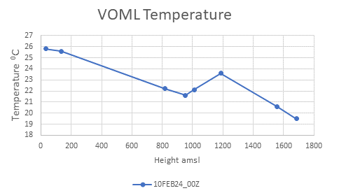
(a) On 10 Feb 2024 temperature at surface was 25.80C and at next report level at 133m amsl was 25.60C. This means a lapse rate of 1.960C/Km that is absolute stability was prevailing. At further next reported level 819m amsl temperature was 22.20C. this means a lapse rate of 5.020C/Km that is conditional instability was prevailing from 133m to 819m amsl. Above 819m amsl inversion was seen.
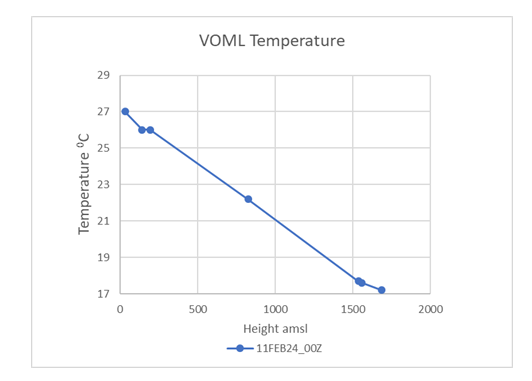
(b) On 11 Feb 2024 temperature at surface was 27.00C and at next report level at 140m amsl was 26.00C. This means a lapse rate of 9.170C/Km that is high conditional instability was prevailing. At further next reported level 193m amsl temperature was 26.00C. this means an isothermal absolute stable layer was prevailing from 140m to 193m amsl. Above 193m amsl next level reported is 825m amsl and had temperature of 22.20C giving rise to lapse rate of 6.010C/Km, a conditionally unstable layer for moist air.

(c) On 12 Feb 2024 temperature at surface (31m amsl) was 26.80C and at next reported level at 65m amsl was 24.00C. This means a lapse rate of 82.350C/Km that is high absolute instability was prevailing. At further next reported level 133m amsl temperature was 25.20C. this means an inversion absolute stable layer was prevailing from 65m to 133m amsl. Above 133m amsl till 438m amsl inversion continued.
6.RH profile is presented below.
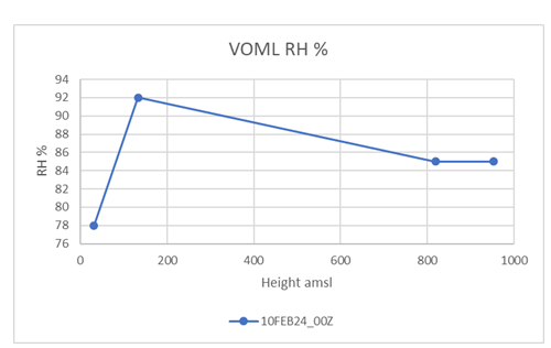
(a) On 10 Feb 2024, RH profile shows that it is increasing from surface (31m amsl) 78% to 92% at 133m amsl and remains above 80% even up to 952m amsl.
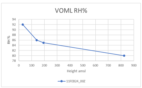
(b) On 11 Feb 2024, RH profile shows that it is decreasing from surface (31m amsl) 92% to 86% at 140m amsl and remains above 80% even up to 825m amsl.
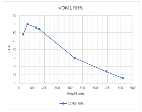
(c) On 12 Feb 2024, RH profile shows that it is increasing from surface (31m amsl) 79% to 85% at 65m amsl and remains above 80% even up to 159m amsl and above 159m amsl reduces below 65%.
7. Conclusion
(a) Absolute stability or conditional instability for moist air favours fog formation. Absolute instability does not favour fog formation.
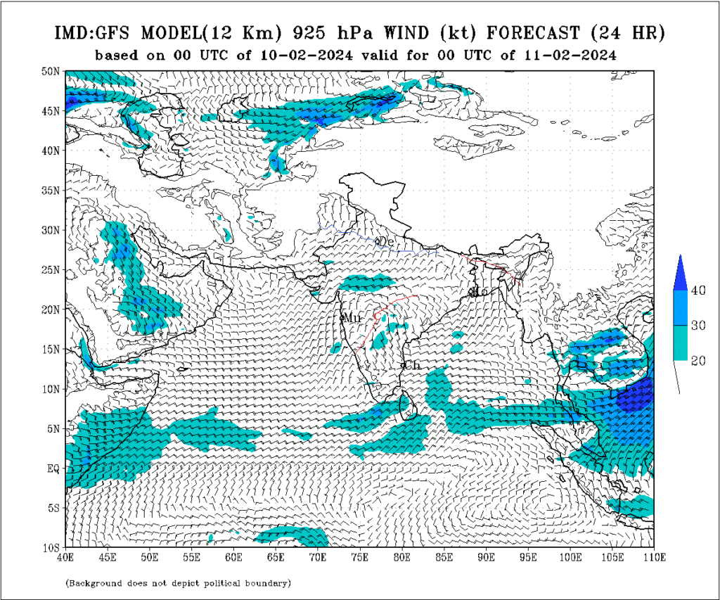
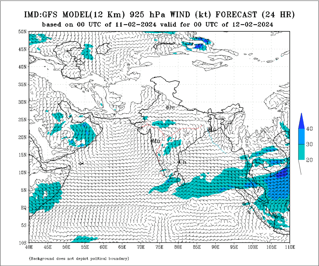
(b) RH profile indicates on fog days RH is above 80% at or above 800m amsl. In other words, it can be said that the chart level 925hPa is involved in fog formation. Fog over coastal Mangalore forms basically because of return current of morning land breeze and descending stratus cloud at table top elevated aerodrome. Hence, the light wind at 925hPa(or westerly wind) favours fog formation. Synoptically light wind near Mangalore region favours good depth of land breeze circulation and strong wind makes it a very shallow land breeze circulation or even circulation does not form
(c) 925hPa charts indicate light winds (05kts or less) on 10 and 11 Feb2024 (fog days) whereas, stronger wind of 10kts are seen on 12Feb 2024 (non-fog day).
(d) 24 hour predicted winds at 0925hPa for 10, 11 and 12Feb2024