By
Gp Capt (Dr) B Nandi
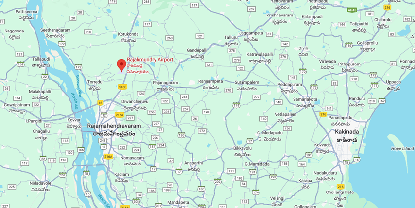
1.Rajahmundry is another place when morning poor visibility is common during winter. to understand occurrences we need to see the topography first.
2.Rajahmundry airport is situated East of Godavari river by about 6-7km distance and about 60 km West of Bay of Bengal. These are two major sources of moisture for Rajahmundry. Map is given below.
During early morning hours, especially in winter land is quite cold in comparison to river water, close by. this sets in the land breeze circulation, that is, at ground wind blows as Easterlies from airport side to Godavari river at ground level and return counter current from Godavari river to airport takes place at little elevated height within about 100m. This return current is highly moist current as plenty of evaporation lakes place into the cold land breeze from warm river water. The counter current descends over land as warm moist air and comes into contact of cold land surface to get cooled giving rise to fog/mist formation. That is how counter current of land breeze becomes favourable for fog formation. Environment becomes more favourable if we have deep layer of moist air over the region
So, we need light eastly wind blowing towards Godavari river near the surface during early morning hours. And to get a deep layer of moist air over the region we need wind from Bay of Bengal in the form of Easterly/ SElies blowing during the major parts of evening/night at 0925hPa ( normally the lowest level of wind in NWP chart, besides 10m wind).
3. 14JAN2024 was a day when fog has taken place over Rajahmundry airport.
(a) Let us examine the METARS of early morning of 14JAN2024.
- VORY 140000Z 09003KT 1200 BR FEW020 23/22 Q1014 NOSIG=
- VORY 140030Z 00000KT 1200 BR FEW020 23/22 Q1014 TEMPO 1000 BR=
- VORY 140100Z 00000KT 0400 FG FEW020 22/22 Q1015 NOSIG=
- VORY 140130Z 04003KT 0200 FG FEW020 23/22 Q1015 NOSIG=
- VORY 140200Z 00000KT 0400 FG FEW020 24/23 Q1016 NOSIG=
- VORY 140230Z 00000KT 0400 FG FEW020 24/23 Q1016 NOSIG=
- VORY 140230Z 00000KT 0600 FG FEW020 24/23 Q1016 BECMG 0700 FG=
- VORY 140300Z 00000KT 0700 FG FEW020 25/24 Q1016 NOSIG=
- VORY 140330Z 32005KT 0800 FG FEW020 26/24 Q1017 BECMG 1000 FG=
- VORY 140400Z 35005KT 1200 BR FEW020 26/23 Q1016 BECMG 1500 BR=
- VORY 140430Z 35004KT 1500 BR FEW020 27/23 Q1016 NOSIG=
METAR indicate fog from 01000UTC to 0330UTC. METAR at 0000UTC and 0130UTC indicates Easterly/NEly winds. Dewpoint depression 10C till 0300UTC and started increasing thereafter. So, this establishes the role of land breeze with Godavari river. NW wind sets in from 0330UTC with rise in temperature to 260C.
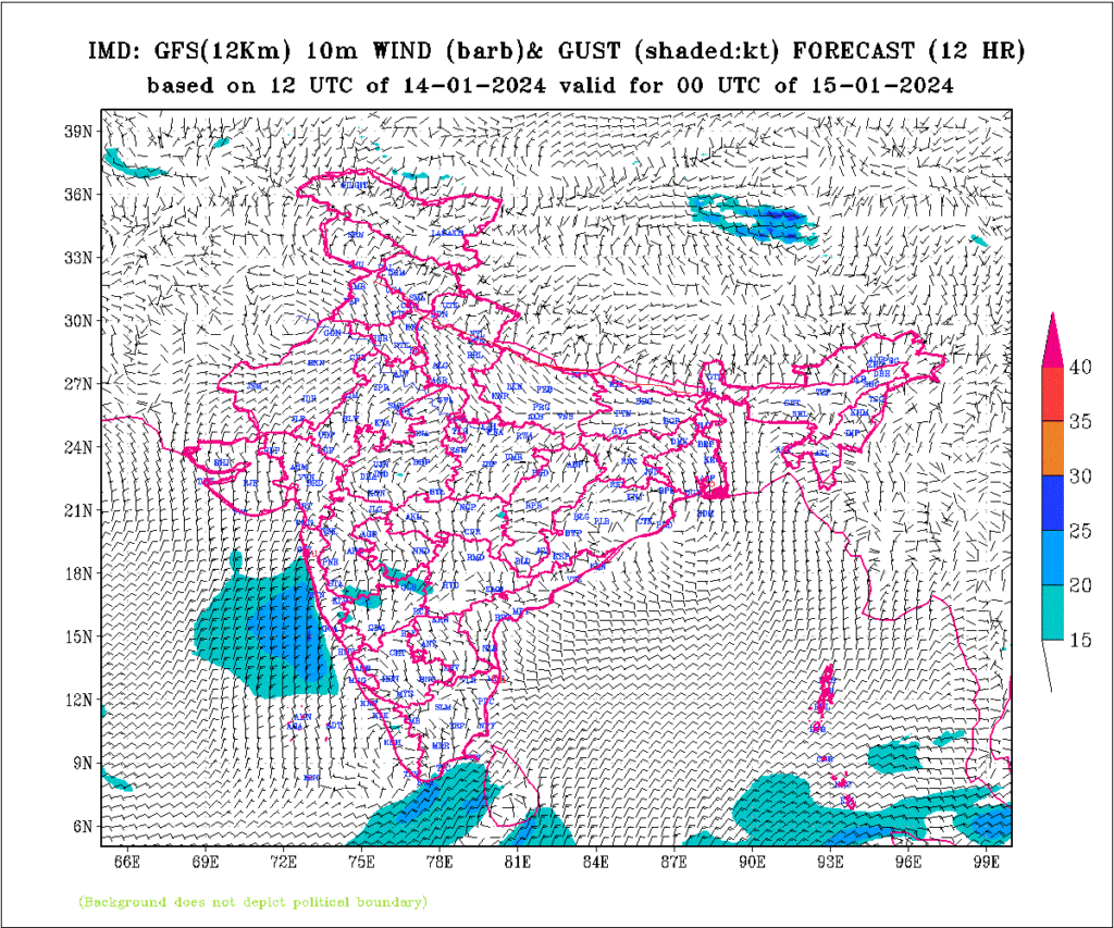
(b) 12 hours predicted 10m wind chart from GFS NWP chart of IMD for for 00Z 14JAN2024 morning shows Ely wind over Rajahmundry.
(c) Let us examine the 925hPa chart of previous day evening that is at 12UTC chart on 13JAN2024.
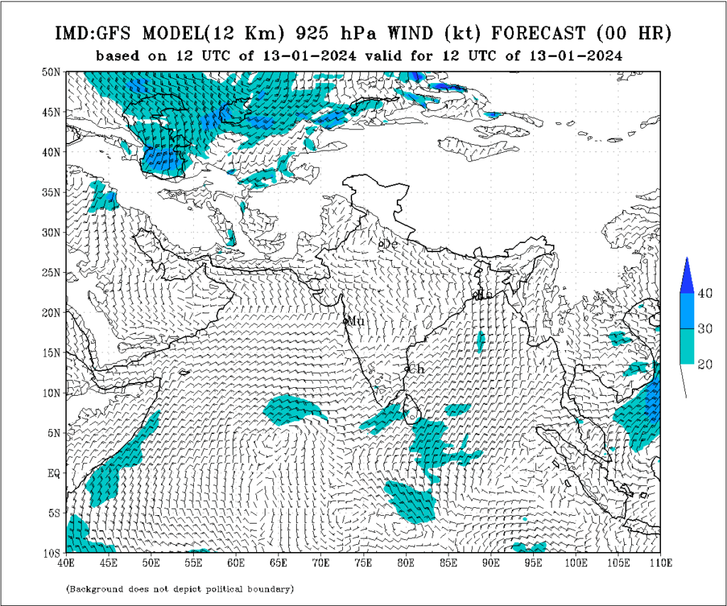
Very light about 02-03kts, SSElies can be seen near coastal Kakinada at 12UTC of 13JAN2024 analysis chart.
(d) The predicted 925hPa chart of previous day mid night that is at 18UTC chart on 13JAN2024 shown below.
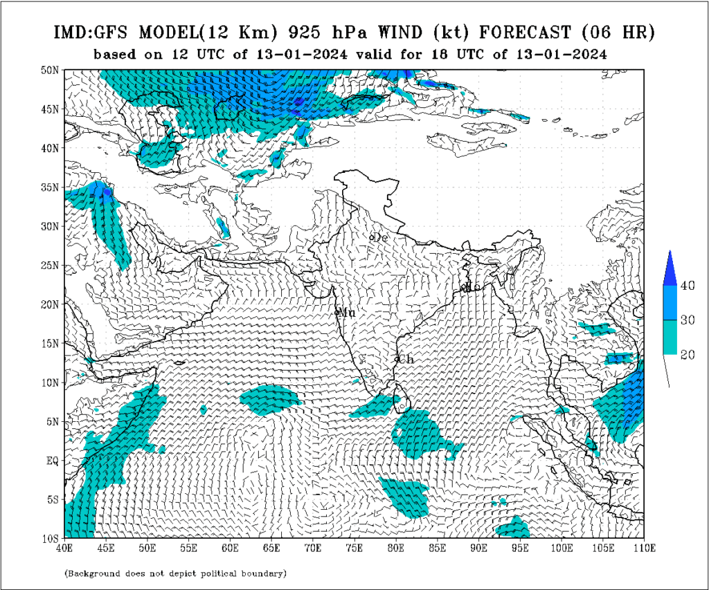
Light SEly of 05kts seen at coastal Kakinada on 18UTC predicted chart of 13JAN2024. This wind direction is good enough for bringing deep layer moisture to Rajahmundry in 6hours time with speed of 10Kmph (05kts).
(e) The METARs of the previous day evening are as follows.
- VORY 130600Z 22005KT 1500 HZ NSC 30/21 Q1015 NOSIG=
- VORY 130630Z 20005KT 1500 HZ NSC 30/21 Q1015 NOSIG=
- VORY 130700Z 23004KT 1500 HZ NSC 30/21 Q1014 NOSIG=
- VORY 130730Z 21007KT 1500 HZ NSC 31/22 Q1014 NOSIG=
- VORY 130800Z 23007KT 1500 HZ FEW020 31/22 Q1013 NOSIG=
- VORY 130830Z 22007KT 1500 HZ FEW020 31/23 Q1012 NOSIG=
- VORY 130900Z 19005KT 1500 HZ FEW020 31/23 Q1012 NOSIG=
- VORY 130930Z 22006KT 1500 HZ FEW020 31/23 Q1012 NOSIG=
- VORY 131000Z 22006KT 1500 HZ FEW020 30/24 Q1012 NOSIG=
- VORY 131030Z 22006KT 1500 HZ FEW020 30/24 Q1012 NOSIG=
- VORY 131100Z 21005KT 1500 HZ FEW020 30/24 Q1012 NOSIG=
- VORY 131130Z 21005KT 1500 HZ FEW020 29/24 Q1012 NOSIG=
- VORY 131200Z 19006KT 1500 BR FEW020 28/24 Q1012 NOSIG=
- VORY 131230Z 20004KT 1500 BR FEW020 28/24 Q1012 NOSIG=
- VORY 131300Z 22004KT 1500 BR FEW020 27/24 Q1013 NOSIG=
- VORY 131330Z 09003KT 1500 BR FEW020 26/24 Q1013 NOSIG=
- VORY 131400Z 11006KT 1500 BR FEW020 25/24 Q1014 NOSIG=
- VORY 131430Z 11006KT 1500 BR FEW020 25/24 Q1014 NOSIG=
- VORY 131500Z 12005KT 1500 BR FEW020 25/24 Q1015 NOSIG=
- VORY 131530Z 11005KT 1500 BR FEW020 25/24 Q1015 NOSIG=
- VORY 131600Z 11005KT 1500 BR FEW020 25/24 Q1015 NOSIG=
- VORY 131630Z 11006KT 1500 BR FEW020 25/24 Q1015 NOSIG=
Initially SWlies maintained moisture from Godavari during day( 0600Z- 1300Z) and by evening SElies maintain the moisture from bay of Bengal. Very light wind at 12UTC chart of 925hPa was indicative of good feasibility of Sea breeze during the day. During entire day dewpoint increased from morning 210C to 240C. Little Range of Dewpoint temperature with high dew point temperatures indicates moist environment being maintained. Situation is ready for fog next day with light wind environment, high moisture given the favourable wind pattern next day morning (Ely at 10m chart).
(f) METARs of 15JAN2024 mornings with fog are as follows
- VORY 150000Z 00000KT 0800 FG NSC 23/23 Q1013 NOSIG=
- VORY 150100Z 00000KT 0500 FG FEW020 23/23 Q1014 BECMG 200 FG=
- VORY 150100Z 10003KT 0200 FG FEW020 23/23 Q1014 BECMG 150 FG=
- VORY 150130Z 00000KT 0150 FG FEW020 23/23 Q1014 NOSIG=
- VORY 150200Z 10004KT 0150 FG NSC 23/23 Q1015 BECMG 200 FG=
- VORY 150230Z 00000KT 0200 FG NSC 24/24 Q1015 BECMG 400 FG=
- VORY 150300Z 00000KT 0400 FG NSC 25/25 Q1016 BECMG 800 FG=
- VORY 150330Z 00000KT 1000 FG NSC 26/25 Q1016 BECMG 1200 BR=
- VORY 150400Z 00000KT 1500 BR NSC 27/24 Q1016 NOSIG=
Watch the Easterly surface wind at 0100UTC and 0200UTC for evidence of land breeze.
4. Conclusion
- Light wind over Rajahmundry is favourable for fog.
- Persistent SEly/Elies at the central coast of Andhra (10m as well as 925hPa) is favourable to supply deep layer of moisture for fog formation.
- Wind pattern should not be strong enough or different enough to inhibit the formation of local land breeze with Godavari river for favourable condition of fog formation. Preferably Easterlies surface wind during morning hours is favourable for setting in the Land breeze and fog with its counter current