By
Gp Capt (Dr) B Nandi
1.Introduction
The atmospheric process that takes place in fog formation and temperature and dewpoint temperature variations is explained with reference to METARs of 06NOV2023 of Amritsar. On this day Minimum temperature was 160C and COT was 190C
2. Usually maximum temperature occurs in the afternoon around 2 to3 hour after local noon on a clear day. This is because Incoming shortwave solar radiation exceeds the outgoing longwave terrestrial radiation till about 2 to3 hour after local noon. Thereafter, the outgoing longwave terrestrial radiation exceeds shortwave radiation and cooling stars. This condition can be altered by following events
- (a) Clouding
- (b) Precipitation
- (c) Cold downdraft from Thunderstorm
- (d) Aerosol (smoke due burning of paddy)
- (e) Thermal advection
- (f) Wind direction in low level.
- (g) Parameters of surface energy balance (like wind speed, moisture and thermal flux in air and in soil, radiations (shortwave and longwave))
3. Let us examine the temperatures of 06 Nov 2023 over Amritsar.
(a) Maximum temperature 290C occurred at 0730Z and 0800Z. It is earlier than usual time. Local noon was at 1211IST (0741Z). 2 to 3 hours after local noon means, 0941Z to 1041Z. What made it early occurrence?
(a) Clouding – Clouding remained SCT040 throughout the day. Clouding can reduce the incoming solar radiation and reduce the outgoing terrestrial radiation as a result there is a slow heating rate and less maximum temperature than clear days. Maximum temperature on 02NOV2023 (with SKC/NSC no clouding) was 300C(0830Z to 0930Z),, on 03NOV2023 was 280C (0830Z to 1030Z), on 04NOV2023 was 300C(0930Z), on 05NOV2023 was 300C(0700Z to 1000Z). On 03NOV2023, 2330Z to 0330Z there was MIFG and SCT040 clouding during 0430to 0530Z resulting lower Maximum temperature.
(b) Precipitation – nil. So, no effect.
(c) Cold down daft from Thunderstorm – nil. So, no effect.
(d) Aerosol – Aerosol content (smoke due burning of paddy) is a source at ground. Near zenith of sun heating becomes rapid as evident in temperature rise pattern. From 0330Z to 0400z temperature was 10C and from 0400Z to 0430Z it is 20C. same is maintained during 0430Z to 0500z. But from 0500Z to 0600Z it is 30C. This heating pattern cause thermals to rise in PBL and distribute Aerosol/smoke particles to a greater depth and blocking the radiations and surface heating becomes slow and temperature reaches its plateau by 0730Z to 0800Z.
(e) Thermal advection – Winds were 30005kt at surface and 27005kt at 0925hPa on 05NOV2023. Meaning backing with height and cold advection. Winds were 07005kt at surface and 11005kt at 0925hPa on 06NOV2023. Meaning veering with height and warm advection. Winds were VRB02kt at surface and 36002kt kt at 0925hPa on 07NOV2023. Meaning nearly nil advection on 07Nov2023 morning 00Z
(f) Wind direction in low level – westerly on 05NOV2023 and easterly on 06NOV2023. Easterly wind forces the aerosol concentration near Amritsar as the source of aerosol is on the NW of Amritsar and light and variable wind on 07NOV2023 morning.
Overall it can be concluded that clouding effected early maximum temperature occurrence.
4. After the occurrence of maximum temperature decrease rate was slow till sunset (at 1208Z). after sunset temperature dropped from 260C to 220C from 1200Z to 1300Z, very rapid drop due to cooling by longwave. This terrestrial radiation keeps reducing as surface temperature keeps reducing. From 1300Z to 1730Z temperature drop was 30C in 4 and half hour, moderate drop. From 1730Z to 0130Z temperature drop was 30C in 8hours, very slow drop.
5. Temperature Range for Amritsar on 06NOV2023. Minimum temperature at 2300Z was 160C and continued till 0200Z then started increasing to Maximum temperature at 0730Z to 0800Z as 290C. So, the range is 130C. Therefore, average decreasing rate from Maximum temperature phase to minimum temperature time can be considered as 130C/15hr= 0.870C/hr. This decrease rate is varying rate.
(a) Near average Cooling phase Max temperature to sunset. Max Temp (0800Z) 290C to 1200Z (around sunset (1208Z)) temperature 260C, means cooling rate is 30C/4hr=0.750C/hr
(b) Extremely Rapid cooling phase. After sunset temperature dropped from 260C to 220C from 1200Z to 1300Z, very rapid drop, means cooling rate is 40C/1hr=4.00C/hr
(c) Moderate Cooling phase. From 1300Z to 1730Z temperature drop was 30C in 4 and half hour, moderate drop, means cooling rate is 30C/4.5hr=0.670C/hr.
(d) Slow/Poor Cooling phase. From 1730Z to 0130Z temperature drop was 30C in 8hours, very slow drop, means cooling rate is 30C/8hr=0.370C/hr.
(e) Heating rate in Max RH phase. From 0130Z to 0400Z temperature increase was 60C in 2.5 hours, very slow rise, means heating rate is 60C/2.5hr=2.40C/hr.
6. Let us follow the dewpoint temperature change. During the phase of Maximum temperature, dewpoint temperature was 190C. It is regarded that at maximum temperature phase thermals of air rises quickly to about a kilometre height in about 10 minutes time frame, churning the entire boundary layer. A mixed layer is established meaning that entire PBL has uniform moisture or in other words constant dewpoint temperature throughout the mixed layer. Temperature lapse rate becomes equal to DALR. So, the air above the PBL, a region not affected by thermals will be warmer and top of PBL will be colder. Giving rise to inversion. A neutral stable PBL forms. The temperature at 100m (T100) height will be 0.980C less than surface air temperature (Ts).
T(100) =Ts – 0.98
So, from the beginning of nocturnal boundary layer one requires surface cooling to be more than 0.980C to form an isothermal layer. Transformation from neutral layer day to isothermal layer takes place in about an hour time. Further cooling of surface temperature inversion of nocturnal boundary layer forms, due to the absence of thermal turbulence and mechanical turbulence. Which is about an hour after sunset. Gradually the cooling effect gain height and increasing the nocturnal boundary layer. If the cooling is such that the condensation starts, the latent heat liberated will make the air warm and rise at SALR, such warm air rising in night makes mixed layer of saturated air with uniform lapse rate as SALR (neutral stable for moist air) and inversion on top of this layer. At this stage we have neutral stable layer for moist air near ground, on top inversion and again above that neutral stable atmosphere for dry air (part of residual layer), topped by inversion layer above the day mixed layer. From saturation time onwards, a further cooling will make dew/fog to form and needs mechanical or moist thermals to condense the whole layer and fog formation. Wind being very light and moist thermals at night is also weak unlike day dry thermals there is a need of convergence for the layer of air to rise and hold the condensed water droplets as fog. When a layer of air rises as in larger scale convergence the top of layer expands vertically more than the bottom of layer thus layer height expands meaning that lapse rate increases facilitating more vertical motion. This is another way convergence helps fog formation.
On 06 Nov23 when temperature started dropping dewpoint also starts dropping. This can happen only when some moisture is removed from atmosphere. Formation and fallout of dew can reduce the moisture. The winds were too light too keep the dews floating. Needed convergence or NVA to keep the dew floating and maintained dew point temperature instead of allowing dew to settle on ground. On 06NOV2023 though 925hPa west-east ridge was just north of Amritsar, the NVA was too weak due very light wind to have any effect of convergence. In spite of high COT of 190C and minimum temperature of 160C, there was no fog formation.
When pressure rises Dewpoint temperature also rises as happened from 0200Z to 0330Z, can be called as max RH phase. To understand this let us see the equation
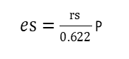
es is saturation water vapour pressure (function of temperature alone)
Rs is saturation mixing ratio
P atmospheric pressure
0.622 is the ratio of the molecular weight of water to that of dry air
Or
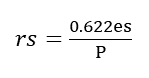
If pressure increases and temperature remains same rs, saturation mixing ratio, decreases. So existing mixing ration may make the atmosphere saturated. In other words, rising pressure phase helps thickening of fog. Pressure decreasing phase helps thinning of fog. Pressure increase tends to increase the dewpoint temperature.
7. Dewpoint variations in different phases of cooling are as follows
(a) Near average Cooling phase Max temperature to sunset. Dewpoint changed from 0800Z to 1200Z is fluctuating between 180C to 200C that is in and around COT of 190C.
(b) Extremely Rapid cooling phase after sunset. Dewpoint changed from 1200Z to 1300Z, unchanged at 190C.
(c) Moderate Cooling phase, first half of night. Dewpoint changed from 1300Z to 1730Z, is 190C to 170C, decrease of about 20C.
(d) Slow/Poor Cooling phase, second half of morning and early morning. Dewpoint changed from 1730Z to 0130Z (one hour after sunrise), is 170C to 160C, decrease of about 10C.
(e) Max RH phase. From 0130Z to 0400Z, Dewpoint rises 160C to 200C.
8. Second half of night onwards change in dewpoint is hardly any it is in the range of 00C to 10C. So midnight dewpoint is good measure for fog forecasting by comparing it with expected minimum temperature. Then comes max RH phase when dewpoint may rise by about 10C to 30C. So, Fog lifting time can be assessed as max pressure reaching time, which is almost 2 to 3 hours after minimum temperature time assuming 20C/hr rise rate.
9. Conclusion
In conclusion it can be said that in the Slow/Poor Cooling phase, second half of morning and early morning temperature decreases at the rate 30C/8hr = 0.370C/hr and dewpoint temperature decrease at the rate 10C/8hr =0.1250C/hr.
This faster rate of cooling of temperature allows to catch up or go below dew point mark because of slower rate of drop of dew point.
VIAR 070130Z 00000KT 0700 R34/1400 MIFG SCT040 16/16 Q1016 NOSIG=
On 07NOV2023 morning at the time minimum temperature dewpoint depression became nil still no fog. On the morning chart (24 hour Forecast chart Appendix 2) ridge at 925hPa was passing through Amritsar (Nly wind) bringing positive vorticity advection from NW.
Fog formation will take place if we have sufficient convergence mainly identified by NVA (Negative Vorticity Advection) at 925hPa and PVA (Positive Vorticity Advection) at 850hPa (A couplet/doublet of convergence and divergence to ensure vertical motion at ground) Fog will easily extend to Max RH phase that is about 0300-0330Z. Since dewpoint rise will takes place on the heels of temperature rise. RH maximum occurs around 0300Z.
Dewpoint temperature goes on decreasing phase to increasing phase, there will be a phase when dewpoint change has to be zero. Usually this constant dewpoint phase occurs in 2330z (1 hour before sunrise to 0130Z (1 hour after sunrise), in the morning. But the usual minimum temperature time usually half an hour after sunrise, this causes thickening of fog after sunrise and further thickening in Max RH phase of rising pressure without rise in temperature. Rising temperature at the rate of 40C/hr (20C in .5hr) will start signalling thinning out of fog.
Appendix -1
METARs
- VIAR 051800Z VRB02KT 1000 R34/2000 BR NSC 19/17 Q1016 NOSIG=
- VIAR 051830Z VRB02KT 1000 R34/2000 BR NSC 19/17 Q1016 NOSIG=
- VIAR 051900Z 06003KT 1000 R34/2000 BR NSC 18/17 Q1016 NOSIG=
- VIAR 051930Z 06003KT 1000 R34/2000 BR NSC 18/17 Q1016 NOSIG=
- VIAR 052200Z VRB02KT 1000 R34/2000 BR NSC 17/15 Q1015 NOSIG=
- VIAR 052300Z 00000KT 1000 R34/2000 BR NSC 16/15 Q1016 NOSIG=
- VIAR 060000Z VRB02KT 1000 R34/2000 BR NSC 16/15 Q1016 NOSIG=
- VIAR 060030Z VRB02KT 1000 R34/2000 BR NSC 16/15 Q1016 NOSIG=
- VIAR 060100Z VRB02KT 1200 R34/2000 BR NSC 16/15 Q1017 NOSIG=
- VIAR 060130Z 07003KT 1000 R34/1700 BR NSC 16/15 Q1017 BECMG 0800 MIFG=
- VIAR 060200Z 07003KT 1000 R34/1400 BR NSC 16/15 Q1017 BECMG 0800 MIFG=
- VIAR 060230Z VRB02KT 1000 R34/1400 BR NSC 17/16 Q1018 NOSIG=
- VIAR 060300Z 00000KT 0900 R34/1100 MIFG SCT040 19/17 Q1018 NOSIG=
- VIAR 060330Z VRB01KT 0900 R34/1300 MIFG SCT040 20/18 Q1018 NOSIG=
- VIAR 060400Z VRB02KT 1000 R34/1300 BR SCT040 21/18 Q1019 NOSIG=
- VIAR 060430Z VRB01KT 1000 R34/1300 BR SCT040 23/19 Q1019 NOSIG=
- VIAR 060500Z VRB01KT 1100 R34/1500 BR SCT040 25/20 Q1019 NOSIG=
- VIAR 060530Z VRB02KT 1200 R34/1600 HZ SCT040 25/20 Q1018 NOSIG=
- VIAR 060600Z VRB01KT 1200 R34/2000 HZ SCT040 28/19 Q1018 BECMG 1500 HZ=
- VIAR 060630Z VRB01KT 1500 R34/2000 HZ SCT040 28/19 Q1018 NOSIG=
- VIAR 060700Z VRB01KT 1500 R34/2000 HZ SCT040 28/19 Q1018 NOSIG=
- VIAR 060730Z 32004KT 1200 R34/1800 HZ SCT040 29/19 Q1017 NOSIG=
- VIAR 060800Z VRB02KT 1200 R34/1700 HZ SCT040 29/19 Q1017 NOSIG=
- VIAR 060830Z 32004KT 1200 R34/2000 HZ SCT040 28/19 Q1016 NOSIG=
- VIAR 060900Z 29003KT 1200 R34/2000 HZ SCT040 28/19 Q1016 NOSIG=
- VIAR 060930Z 32004KT 1200 R34/2000 HZ SCT040 28/19 Q1016 NOSIG=
- VIAR 061000Z 32004KT 1200 R34/2000 HZ SCT040 28/19 Q1015 BECMG 1500 HZ=
- VIAR 061030Z 32004KT 1500 R34/2000 HZ SCT040 28/18 Q1015 NOSIG=
- VIAR 061130Z 32003KT 1200 R34/2000 HZ SCT040 26/19 Q1015 NOSIG=
- VIAR 061200Z 32003KT 1200 R34/2000 HZ SCT040 26/20 Q1015 NOSIG=
- VIAR 061300Z 00000KT 1200 R34/2000 HZ SCT040 22/19 Q1015 NOSIG=
- VIAR 061400Z VRB01KT 1200 R34/2000 BR SCT040 21/19 Q1016 NOSIG=
- VIAR 061430Z 00000KT 1200 R34/2000 BR SCT040 20/18 Q1016 NOSIG=
- VIAR 061530Z VRB02KT 1200 R34/2000 BR SCT040 20/18 Q1017 NOSIG=
- VIAR 061730Z VRB02KT 1200 R34/2000 BR SCT040 19/17 Q1017 NOSIG=
- VIAR 061800Z 00000KT 1200 R34/2000 BR SCT040 19/17 Q1017 NOSIG=
- VIAR 061830Z 00000KT 1200 R34/2000 BR SCT040 19/17 Q1017 NOSIG=
- VIAR 061900Z VRB01KT 1200 R34/2000 BR SCT040 19/17 Q1017 NOSIG=
- VIAR 061930Z VRB01KT 1200 R34/2000 BR SCT040 19/17 Q1017 NOSIG=
- VIAR 062000Z VRB01KT 1200 R34/2000 BR SCT040 18/17 Q1017 NOSIG=
- VIAR 062030Z VRB02KT 1200 R34/2000 BR SCT040 18/17 Q1016 NOSIG=
- VIAR 062100Z 00000KT 1200 R34/2000 BR SCT040 18/17 Q1016 NOSIG=
- VIAR 062130Z 00000KT 1200 R34/2000 BR SCT040 18/16 Q1016 NOSIG=
- VIAR 062200Z 00000KT 1200 R34/2000 BR SCT040 18/16 Q1016 NOSIG=
- VIAR 062230Z VRB02KT 1200 R34/2000 BR SCT040 18/16 Q1016 NOSIG=
- VIAR 062300Z VRB02KT 1200 R34/2000 BR SCT040 18/17 Q1016 NOSIG=
- VIAR 062330Z 00000KT 1000 R34/2000 BR SCT040 17/16 Q1016 BECMG 0800 MIFG=
- VIAR 070000Z VRB02KT 1000 R34/2000 BR SCT040 17/16 Q1016 BECMG 0800 MIFG=
- VIAR 070030Z VRB02KT 1000 R34/1900 BR SCT040 17/16 Q1016 BECMG 0800 MIFG=
- VIAR 070100Z VRB02KT 1000 R34/1800 BR SCT040 17/16 Q1016 BECMG 0800 MIFG=
- VIAR 070130Z 00000KT 0700 R34/1400 MIFG SCT040 16/16 Q1016 NOSIG=
- VIAR 070200Z 00000KT 0700 R34/1400 MIFG SCT040 17/16 Q1016 NOSIG=
- VIAR 070230Z VRB02KT 0700 R34/1200 MIFG SCT040 18/16 Q1017 NOSIG=
- VIAR 070300Z 00000KT 0700 R34/1100 MIFG NSC 19/18 Q1017 BECMG 0800 MIFG=
- VIAR 070330Z VRB01KT 0800 R34/1200 MIFG NSC 20/18 Q1018 NOSIG=
- VIAR 070400Z 00000KT 0800 R34/1200 MIFG NSC 22/20 Q1018 NOSIG=
- VIAR 070430Z 00000KT 0900 R34/1400 MIFG NSC 24/20 Q1018 NOSIG=
- VIAR 070500Z VRB01KT 1200 R34/1700 HZ NSC 26/20 Q1018 BECMG 1500 HZ=
- VIAR 070530Z VRB02KT 1200 R34/1900 HZ NSC 26/20 Q1018 BECMG 1500 HZ=
- VIAR 070600Z 32003KT 1200 R34/1700 HZ NSC 26/20 Q1018 NOSIG=