BY
Gp Capt (Dr) B Nandi
- Introduction
The very essence of weather forecasting lies in identifying areas of vertical upward motion. Which in turn when moisture is present produces clouds and different types of clouds produce different kinds of weather like drizzle, rain, shower, thundershower with hail or without hail, squall line, MCC etc.
2. Methodology
The methodology for identifying areas of vertically upward motion basically lies on few principles of meteorology
- (a) Simplified Vorticity Theorem which gives a way to identify where convergence and divergence taking place in terms of vorticity advection. Positive vorticity advection (PVA) leads to divergence and negative vorticity advection (NVA) leads to convergence. Thus wind blowing from trough of low will carry positive vorticity advection and wind blowing to trough of low will bring negative vorticity advection. Similarly, wind blowing from ridge carry negative vorticity advection and wind blowing to ridge will bring positive vorticity advection. so, we say ahead of trough has divergence and rear of trough has convergence. similarly ahead of ridge convergence and rear of ridge has divergence.
- (b) Quasi-geostrophic omega equation which provides the region of vertical motion in terms of differential vorticity advection and warm/cold air advection
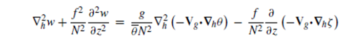
- The second term on the lefthand side becomes negligible for small f of low latitude and high static stability (i.e large N) and in that case response of vertical velocity depends on the horizontal motion. Warm air advection and upward increase of geostrophic vorticity advection favors upward vertical motion. Large convergence gradually decreasing to non-divergence and the increasing in divergence with height is ideal for large vertical motion. In other words, differential vorticity advection is important for vertical motion.
- (c) Principle of Dines compensation. Dines compensation principle is a meteorological concept stating that converging winds at one altitude are balanced by diverging winds at another altitude, and vice versa, within a column of air that is in any column of air, the horizontal divergence must change sign (from convergence to divergence or vice versa) at least once with height.
- Another way a Dines’ compensation suggests that if air is rising in one part of the atmosphere (e.g., at the center of a thunderstorm), there must be a corresponding area of sinking air elsewhere to maintain a balance in the total air mass. A low-pressure area must have associated high pressure area to maintain the balance in atmosphere.
3. Working principles
Based on the above principles we work out the working rules for finding where vertical upward motion is possible
- (a) Identifying the areas of convergence at lower level close to ground and above at least up to the level of 850hPa (1.5 km) along with divergence above level of non-divergence (LND) that is at upper troposphere (say 300hPa)
- (b) Identifying the areas of convergence at lower level close to ground and above at least up to the level of 850hPa (1.5 km) along with unstable atmosphere above at least till mid-troposphere.
- (c) Orographic lift by anabatic wind aided by anticyclonically turning synoptic wind (converging wind) or by sea breeze to hills.
4. Convergence/Divergence
Convergence (accumulation of air)/divergence (depletion of air) are assessed by following methods
- (a) NVA/PVA. When wind comes from high positive vorticity area it is PVA. When wind comes from nil vorticity region to negative vorticity region (wind blowing towards ridge) it is also PVA. Divergence is caused by PVA. When the wind comes from negative vorticity region (wind blowing away from ridge) it is NVA. When wind comes from nil vorticity region to positive vorticity region (wind blowing towards the trough) it is also NVA. Convergence is caused by NVA. The above statements are as per vorticity theorem of Dynamics of meteorology.
- (aa) Magnitude of curvature vorticity is higher for smaller radius (sharp curvature) and higher wind speed as centrifugal force is proportional to square of velocity and inverse of radius of curvature. (vorticity equation)
- (i) Cyclonic curvature is associated with positive vorticity. Trough of low pressure is associated with cyclonic curvature and positive vorticity region is only close to trough. So, the PVA/NVA region extends about 200Km at low level where winds are usually less and about 500km in upper troposphere where wind is high. In the case of trough of very high curvature the extent of vorticity may not extend beyond 100km.
- (ii) Anticyclonic curvature is associated with negative vorticity. Ridge of high is associated with anticyclonic curvature and negative vorticity region is only close to ridge. So, NVA/PVA region extends about 200Km at low level where winds are usually less and about 500km in upper troposphere where wind is high.
- (ab) Higher the speed difference, higher is the shear vorticity in magnitude.
- (i) Cyclonic shear is associated with positive vorticity. So downstream of cyclonic shear will get PVA and thus divergence and upstream will get NVA and thus convergence.
- (ii) Anticyclonic shear is associated with negative vorticity. So, the downstream of anticyclonic shear will get NVA and thus convergence and upstream will get PVA and thus divergence.
- (aa) Magnitude of curvature vorticity is higher for smaller radius (sharp curvature) and higher wind speed as centrifugal force is proportional to square of velocity and inverse of radius of curvature. (vorticity equation)
- (b) Speed divergence/convergence. Away from curvature in flow of wind convergence and divergence is governed by speed difference in wind. If incoming wind is stronger than the outgoing wind that region has convergence, if weaker it is divergence.
- (c) Confluence/Difluence. When streamline laterally comes closer it is confluence, does apart it is difluence. Usually, two different streams in confluence is source of convergence, streams in difluence are source of divergence.
- (d) Latitude effect. With gain in latitude Coriolis force increases, thus under same pressure gradient wind speed decreases. This gives rise to Converging characteristics to Southerly wind and diverging characteristic to Northerly wind.
- (e) Wind Discontinuity. At wind discontinuity the wind comes from opposite direction and converges. Usually, discontinuity surface has slope with height. Convection develops initially at low level position during afternoon then spreads in the direction of slope as the day progresses.
- (f) Vertical Component of Coriolis Force. Vertical component of Coriolis force is upward, favoring westerly wind to have tendency to go up and easterly wind to go down or subside. Combination of latitude effect and vertical component of Coriolis force makes South Westerly wind prone for weather producing and North Westerly wind prone for subsiding.
5. Evaluation
We cannot form a thumb rule that ahead of the trough is divergence and rear is convergence. There may be effect of speed, shear, confluence etc. We need to evaluate each component as mentioned above to understand the pattern of weather formation. The best way of doing things is to match the satellite image during NWP input of wind at analysis time. This would give confidence in evaluating divergence convergence patterns in subsequent charts and forecasting based on wind charts.
6. Peninsula, Strait, Island, Valley, Foothills
- (a) Over Peninsula, Sea breeze from both the oceanic side convergence over peninsula forming a wind discontinuity and mostly responsible for night clouding over land mass. During early morning when land breeze sets in, the wind diverges from land mass to ocean creating subsidence and clear clouds during early morning. On windward side of peninsula, the land breeze forms an offshore discontinuity at low level and the convective cloud thus formed are drifted by the largescale wind to land mass causing early morning showers.
- (b) Over Strait, opposite of Peninsula happens. During night Sea breeze diverges from Strait to land giving clear weather and during early morning Land breeze converges over the ocean giving rise to clouding over strait.
- (c) Island being surrounded by ocean Land breeze diverges from land during early morning and minimum clouding occurs during this time. While during Sea breeze time wind converges from all direction to give rise to clouding over Island.
- (d) Valley weather is dominated by Katabatic wind, Anabatic wind and Valley wind. The valley gets clearer during the afternoon due to divergence caused by anabatic wind and its counter-current descending over the valley. Whereas katabatic wind causes convergence over the valley and rises to give cloudy during night. For one side open valley during late afternoon entire valley becomes warm including the side wall of mountain anabatic wind stops and valley wind from open mouth to valley starts. This valley wind blowing into the valley rises at the end of valley and give rise to clouding. Similarly early morning when entire valley (one end open) becomes cold, katabatic wind ceases and valley wind from valley to open mouth starts clearing the valley weather.
- (e) Foothills get rising motion due to Katabatic wind rises over the foothills and returns to hills to complete the katabatic circulation. This rising motion mostly inhibits fog over the foothills station. The counter part of anabatic wind descends over the foothills during afternoon making afternoon sunny.
7. Conclusion
We have quality prediction of wind field by NWP model. Careful assessment from wind charts of various level of convergence/divergence and its vertical distribution will lead to correct evaluation of vertical velocity and thus pattern of clouding and weather forecast. Single distribution of Convergence decreasing with height and increasing as divergence from level of non-divergence is expected to be associated with area of thunderstorm. Convergence in major parts of lower and mid troposphere with divergence aloft leads to weaker vertical motion resulting in layer cloud and rain. with number of intervening divergence layer amongst convergence will create multi layer clouding and some rain. Central dense overcast part of cyclone/depression produces lots of rain/shower than thunderstorm. Vertical motion near ground and subsidence aloft mostly leads to fog/low cloud. Mid tropospheric condition of vertical velocity can be observed through Water Vapour satellite image. The black zone in Water Vapour image is associated with descending motion and white zone signifies the area of moisture in mid troposphere. The subsidence can be observed from the Skew-T gram/Tephigram with the large spread of dewpoint and environmental curve denoting large dewpoint depression. Drying in the atmosphere is mainly done by the subsidence.